

By Paul Weideman
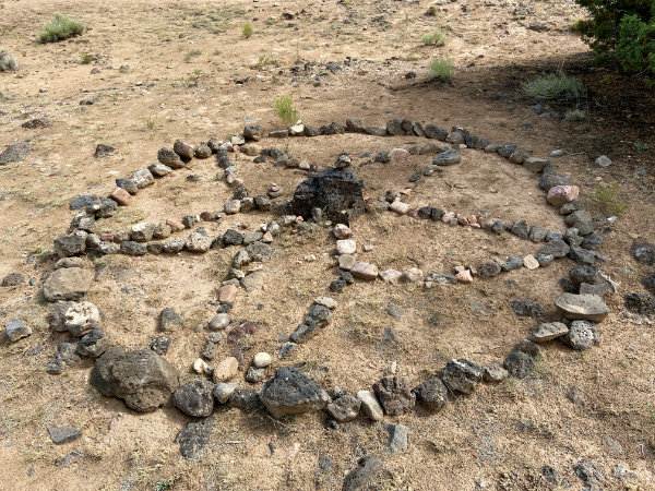
Messing with the matrix. That’s one of the problems with the modern-day fad of stacking stones into cairns in wilderness areas. Cairns are an age-old method of marking trails, but those that are constructed for less serious reasons at archaeological sites can cause irreparable damage.
“If there were associated grid gardens or shallow subsurface deposits, the rock removal would likely disturb them, compromising the shallow subsurface stratigraphy,” says Jessica Badner. A field archaeologist for about two decades, she is now the coordinator of New Mexico SiteWatch, a network of trained site stewards who monitor the state’s historic and prehistoric resources as part of a program of the New Mexico Department of Cultural Affairs’ Historic Preservation Division. Badner once excavated an archaeological site that had a time depth of thousands of years less than four inches from the surface.
“We have amazing Archaic sites throughout New Mexico, and some are deeply buried and some are not,” Badner says. “The site I’m talking about is in the Santa Fe area. We have extreme time depth in some very shallow sites, so a lot of damage can be done. The effect of moving stones at a site is cumulative. For example, pollen samples from intact grid gardens can tell species of plants that were cultivated and can provide a season of occupancy. The interface between an undisturbed cultural horizon, or floor, and a rock can provide a prime sampling location—but if the rock has been popped out, that special context is contaminated with other environmental pollen and the sample is no good.”
A lot of this hinges on an arguably subtle and esoteric quality: the record of past human activities that exists in the layered “sequence” of a site’s earth, stone, or other natural material. The archaeologist says the SiteWatch program is “really important to preserving the story” of past peoples that can be read in the landscape.
“It’s very Poindextery, and that’s kind of the funny part about archaeology: It can be really neat and exciting, but a lot of times what you end up with is a very particular way of talking about it that isn’t exciting.”
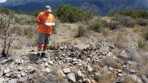
New Mexico SiteWatch is managed by the Historic Preservation Division and funded by the State of New Mexico, the U.S. Bureau of Land Management, and the U.S. Forest Service. Its volunteer stewards adopt and routinely monitor archaeological sites, historic buildings and trails, bridges, and other features for signs of erosion, wear and tear, vandalism, and looting.
Badner coordinates the activities of about 130 stewards, who collectively drive some 30,000 miles every year to perform their mission. She trains stewards “to know why they’re monitoring and how to classify what they find,” she describes. Some of the impacts to sites are purely natural, like animals burrowing or wildfires that result in flash floods and erosion.
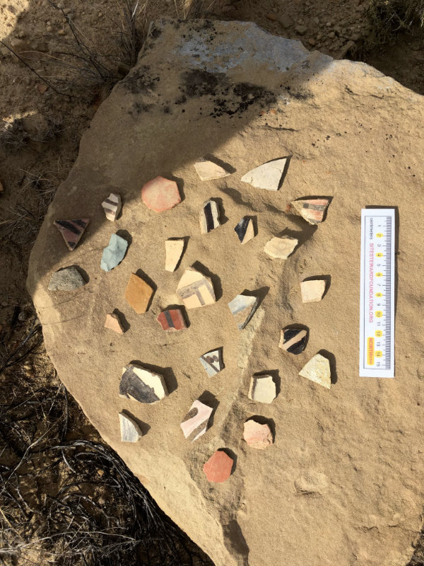
The classes of site degradation that are human-caused run the gamut. Like stone-stacking, another activity that only seems innocuous is when people find pretty potsherds and arrange them on a flat rock. “That’s not great because it causes a rift in the integrity of the context,” Badner says. “People may be well-meaning, showing a desire to share what they’re experiencing with other people—’Hey, look, we found a cool sherd. Look what’s here!’—They’re trying to share their experience with their fellow visitor within the parameters of what they understand to be acceptable behavior. Nothing’s going off-site, so people don’t see it as an issue. It’s not done with nefarious intent. If it were just five or so sherds, okay, it’s not ideal, but in the grand scheme of things it’s a relatively small impact. But multiply that over 20 or 30 years of site visits.
“They don’t realize that they’re changing the spatial relationship of those materials. That would be something our stewards would report and the land managers would make a decision, maybe to put up signs or they may decide to have a ranger on hand for crowded days.”
Among the other categories that stewards encounter are trash-dumping; illegal woodcutting and out-of-bounds ATV use; damage from wandering cattle; and vandalism and looting. Once reported by stewards, the land manager may decide that it’s a crime scene, then law enforcement takes over.
Badner helps put the puzzle together in cases where a land manager expresses concern about activity at a particular site. She may decide to call the area coordinator to see if there’s someone to monitor it.
The volunteer stewards, many of whom are retirees, often spend an entire day getting to and monitoring a site. “We have a lot of stewards who have had very full work lives, a lot in demanding professional situations, and the type of people who want to serve are those who really want to make a difference,” Badner says.
“I really admire our Site Stewards. These are not people who show up at a gala and write a check. They’re doing a lot of work as volunteers, and sometimes with very little recognition. And if a situation goes into the black box of law enforcement, the coordinator will ask them not to go visit that site for a while.”
Badner says the past year has been busier than ever because of the COVID pandemic; there are a lot more people on the land. For Sandra Arazi-Coambs, the Sandia/Tijeras chapter coordinator for SiteWatch, that means trouble as more and more housebound citizens want to hit the trails. “I work outside the city of Albuquerque, so some of the vandalism is graffiti,” she says.
Arazi-Coambs is the Sandia/Mountainair zone archaeologist and also a land manager with the Cibola National Forest and National Grasslands.
“We have over 10,000 recorded sites, and we have not surveyed a lot of that area,” she says. “We have five or six staff archaeologist positions, so there’s no way we can monitor even just the significant sites. Of the 10,000, there are about 100 particularly significant sites that we think would be vulnerable. New Mexico SiteWatch volunteers allow us to have eyes and ears on the ground.”
In a December 2020 interview, Arazi-Coambs said she was dealing with a new example of the kinds of impacts that can happen to historic features. This one involved a Sandia Mountains picnic area that was built by the New Deal-era Civilian Conservation Corps.
“We get so much vandalism in the foothills because these sites are accessible. We had volunteers who had reconstructed one of the picnic tables. It’s really cool. The CCC had suspended a picnic table from a chain attached to a boulder. We have a picture of it from the 1930s, and our volunteers sized it just right so it would conform to how it was built. I just found out that the table was recently vandalized. They took it off the chain that was suspending it and did some graffiti. It’s really discouraging.”
In this context, the term “historic” means at least 50 years old, and the CCC table satisfied that criteria with about 35 years to spare. An “archaeological site” is anything that’s 50 years or older and meets the National Register of Historic Places criteria for significance; according to New Mexico administrative code, it is a location where there exists “material evidence of the past life and culture of human beings.” Examples include pueblos, homesteads, campsites, and artifact scatters. By state law, most of these sites are also anonymous; their locations are not public knowledge.
“We have these big sites like Chaco Canyon and Mesa Verde that are clearly unique, that kind of punch you in the nose,” Badner explains. “We call those the sexy sites. But we also have fairly ephemeral sites that are culturally and scientifically important even though they’re not a big wow. Some of our mining sites are in that category. A site can be significant because of its contribution to knowledge or because of its association with important people, but also because of its documentation of the winds of history. Some of those mining sites can answer questions like, ‘What was going on in society during this time?’”
Illegal digging is the main problem for Peter Lipscomb at Cerrillos Hills State Park, which is known for its mining history. “People think mines mean they can come out here and just dig, but these are protected cultural sites,” he says. “And as is true on many public lands, collecting, metal-detecting, and prospecting are off limits; they’re against the law. They are monitored and activities are documented and information is shared with law enforcement.”
The rules for the park (which has been closed to all but New Mexico residents since July 2020) are posted on trailside signs. Stewards working here enjoy a realm of big skies and long views of the surrounding mountains. It’s a land of roadrunners and bobcats, of soaring red-tailed hawks and bats. Along the flinty trails—five miles of them—that wind through the hilly piñon-juniper landscape, you encounter cholla and prickly pear, mountain mahogany and four-wing saltbush, and, of course, abandoned mines.
During a site visit, we came onto a big black hole in the ground, covered with steel netting and perimetered by a low barrier of black steel railing. There’s no way you can miss such historic abandoned mines. On the other hand, examples of illegal digging can be subtle, like the slight depression further down the trail that was less than 12 inches in diameter. “I can distinguish what an animal does compared to what a human does,” Lipscomb said when he noticed it. “This is a prospect pit.”
SiteWatch volunteers learn how to read those signs to monitor mine sites. The park has had a cooperative program with Badner’s organization for a little over a year.
“Earlier in 2020 we had a rash of incidents, six in a row at one site on the Cortez Mine Trail,” Lipscomb says. “There’s the illegal side, but there’s also the disrespect of the shared cultural identity of the people who were here and their stories.”
He believes mining is the park’s most important narrative. “It’s how the natural history influenced the cultural history and multicultural settlement of New Mexico, from Indigenous cultures to Spanish explorers, and on up to Territorial mining. These little hills tell a big story.”
There is evidence here not only of Ancestral Puebloans who lived in the area a thousand years ago, but of Archaic and Paleoindian migrants going back 10,000 years. “This was winter hunting ground for people coming out of the Jemez and the high country,” Lipscomb says. “There can be evidence of transient campsites. You get potsherds and lithic scatters from flintknapping. There are some places where we have metates and stone mauls.”
The park is at the end of a mile-long vein of galena, a lead-silver sulfide. Native people ground galena into pottery glaze starting in about 1300 CE, but they focused on the area around the Cerrillos Hills’ Mount Chalchihuitl four centuries before that to mine turquoise. “All you needed was a rock harder than what you were working,” according to Lipscomb. “You had to be very skilled at using a stone hammer to get turquoise, for example, to not destroy what you were seeking.”
SiteWatch volunteers also monitor features left by Spaniards who sought lustrous metals—not only galena but silver, lead, copper, iron, zinc, and manganese—beginning in the late 1500s, and then by Territorial U.S. miners during a boom in the late 1870s and early 1880s. Archaeological sites in Cerrillos Hills State Park also include stone foundations for Territorial-era tent platforms.
Overall, New Mexico SiteWatch monitors for the BLM; the Gila, Lincoln, Carson, and Cibola national forests; Santa Fe County; Bandelier National Monument; Chaco Culture National Historical Park; the Archaeological Conservancy; the Wells Petroglyph Preserve; New Mexico State Parks; and the State Land Office. The two other major New Mexico stewarding programs are more localized: Santa Fe National Forest Site Stewards and Northwest New Mexico Site Stewards.
“Our most common problem is erosion; just the natural forces of the climate and weather,” says Will Dearholt, chairman of the Santa Fe National Forest Site Stewards Program and one of its area team leaders. Natural forces have collapsed 800-year-old walls. Segments of ancient walls are not too rare in the national forest, although many are only hip-high.
There is also the issue of cattle tromping over archaeological sites. However, off-road and out-of-bounds vehicles pose a greater threat. The numbers of forest visitors, particularly in the Jemez, has increased greatly in the pandemic. And many of those visitors are people who are not used to taking care of the land.
“They bring huge numbers of vehicles and stuff, great big RVs and ATVs. There are places where it almost looks like they’re setting up a town,” Dearholt says. “Some archaeological sites are not obvious. They don’t look like much—it’s not Mesa Verde—so you can imagine why people don’t know what it is and go ahead and do a wheelie over it with their ATV.”
The all-volunteer Santa Fe National Forest Site Stewards goes back to about 1998. Since then, volunteers have helped to monitor priority sites, assisted with identification and documentation, and researched cultural resources. “The Forest Service’s heritage resource program manager assigns us sites,” Dearholt says. We go out and check sites about once a month.”
The Santa Fe National Forest is vast, encompassing more than 2,400 square miles and including nearly 300,000 acres of wilderness. Ancient peoples inhabited these lands, and some left pictographs and petroglyphs. “Some of the archaeological sites do have those and people shoot at them or chip away with a hammer and chisel,” Dearholt says.
In northwestern New Mexico, Navajos painted and pecked beautiful figures onto the face of a sandstone cliff at Bi-Yazh about 350 years ago. In the late 1980s or early 1990s, thieves chiseled off three rectangular panels from the stunning site.
The site is in Largo Canyon, a good 60 miles south of Bloomfield, says Larry L. Baker, executive director of Northwest New Mexico Site Stewards. “Two of the panels that were removed from Bi-Yazh we have on display here at the Salmon Ruins Museum [in Bloomfield] on semi-permanent loan from the Museum of New Mexico. … They’re under the stewardship of the Bureau of Land Management. When they were removed, they were sold in Santa Fe. BLM law enforcement was able to chase that and actually recovered two of the three. There’s still one out there, but law enforcement doesn’t feel that they have enough evidence yet to get the search warrant.”
The bureau removed others in Pueblo Canyon, afraid that the same thing would happen again. “Somebody had gone in and started drilling holes, so when BLM identified that, they decided to go in and remove the panels,” Baker says. “They were at the Wheelwright Museum of the American Indian in Santa Fe, and they were ultimately sent to the Navajo Nation Museum in Window Rock.”
Fortunately, such dramatic cultural thefts have not reoccurred. Volunteers with Northwest New Mexico Site Stewards have been patrolling the area since 1999. An original site stewards program began in the late 1980s, but lapsed. “Through the 1990s we began to see an increase in looting and vandalism, and we decided to re-institute the program. We’ve been operating it consistently with the BLM; our program is an internal division of the San Juan County Museum Association, which operates the Salmon Ruins Museum.”
The group monitors sites under the jurisdiction of the BLM, the Bureau of Reclamation, New Mexico Game & Fish, the State Land Office, and some private property, including two sites for the Archaeological Conservancy. A current patrol focus is the prehistoric Great North Road north of Chaco Canyon.
“The other thing that my site stewards do is monitor Navajo defensive sites that have standing architecture. If they see that a wall is deteriorating or there is an issue involving damage, they will make a note of that and inform me, and I’ll go out with my co-directors and we’ll make an assessment and report it to the BLM.”
Baker says it’s usually during times of a tough economy like we have now that looting activity begins to increase. “Someone can go out and find a pot and sell it. But we have been very fortunate in the past two decades to have seen very few violations. We’ve only seen one instance of recent looting—digging—at a historic ranch site on private property. Over the last ten years we’ve seen a few instances of vandalism, where people have shot holes in rock-art panels or have taken charcoal and wrote their names and stuff. But I think it says that we’re making a difference, just going out there, having a presence.”
For more information, visit individual program websites:
nmhistoricpreservation.org/programs/sitewatch.html
salmonruins.com
—
Paul Weideman has written about archaeology, historic preservation, architecture, real estate, art, and culture for The Santa Fe New Mexican and other publications for 30 years. He is the author of the 2019 book ARCHITECTURE Santa Fe: A Guidebook.