An American Pilgrimage:
Hiking the Great North Road
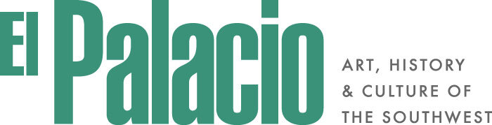
 Sunrise on the Acropolis. Broken pieces of Kira Enriquez’s ceramic vessel
remain after the author’s funerary ceremony in honor of Scott Tsoodle.
Sunrise on the Acropolis. Broken pieces of Kira Enriquez’s ceramic vessel
remain after the author’s funerary ceremony in honor of Scott Tsoodle.
By Scott Robinson
The North Road has been on my backpacking bucket list for years. Only one person, adventurer-journalist Craig Childs, documented walking the entire length of the North Road nearly two decades ago in House of Rain: Tracking a Vanished Civilization Across the American Southwest. When I learned that my childhood friend, Scott Tsoodle, had recently passed away, I began making plans to hike the North Road as a way of saying goodbye.
Roughly the same time as the Camino de Santiago cult was gaining traction in Medieval Europe, an extraordinarily straight, 30-foot-wide, groomed pilgrimage trail called the Great North Road spanned 33 miles north from Chaco Canyon to Kutz Canyon in northwestern New Mexico. There is no trail to follow today, and signs of its existence are mostly invisible without satellite or LiDAR imagery. But as Keith Basso pointed out in his influential book, Wisdom Sits in Places: Landscape and Language Among the Western Apache, the desert landscapes of the Southwest are anything but empty.
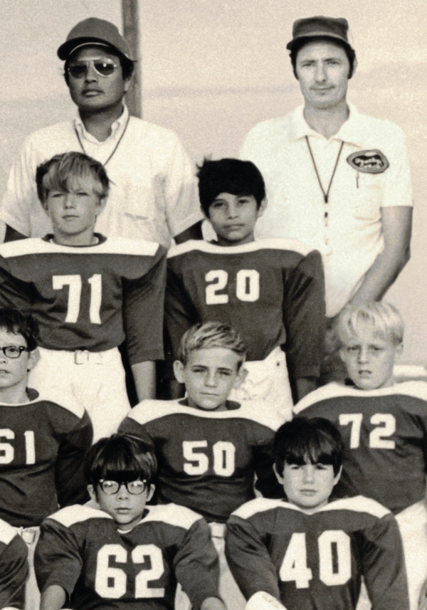
Scott and I were best friends as kids growing up together in Texas before his family moved back to their Kiowa homeland in Oklahoma. We were on the same youth track and field team in the summer of 1971 and played football together the following fall. Our friendship, as brief as it was, shaped the way I grew to understand American history as an adult.
In 2019, I dug up an old photo that spurred me to do an internet search for my friend. I learned that Scott had died just a few months earlier. The photo I found shows ten-year-old Scott Tsoodle surrounded by white faces, including mine, as teammates on a pee-wee football team in 1971. My father caused raised eyebrows when he invited Scott’s father, Duke Jr, to join him on the coaching staff of that all-white youth league football team.
Coach Tsoodle had brought his family to Fort Worth near the end of extremely controversial and damaging federal policies initiated in the mid-1950s, collectively known as “termination and relocation”—terminating reservations and relocating Native people to cities—which was intended to move them out of rural poverty and into the mainstream of urban economic opportunity. In some ways, these policies were the latest government effort to assimilate Native Americans into non-existence. With or without federal relocation programs, however, Indian Country had been steadily spreading into urban areas since WWI. Duke Jr. was employed by the Bureau of Indian Affairs to assist Native people in making the transition to urban life in the Dallas-Fort Worth area.
Scott and I were typical American kids. We shared sports obsessions, sleepover shenanigans, and AM radio pop music. At the same time, the Vietnam War and social unrest loomed in the background. America was still reeling from the Kent State shootings a year before. School board protests over federally mandated desegregation of our public schools dominated the local news. Emblematic of the national Chicano Movement, La Raza Unida Party had just formed in Crystal City and would soon win campaigns in local elections throughout the Rio Grande Valley of Texas. The Women’s Liberation Movement gained impressive momentum as the contentious Equal Rights Amendment, hotly debated in Washington and around dining tables nationwide, was passed by the U. S. House of Representatives in the autumn of 1971 and was months away from being placed before the states for ratification. Marvin Gaye’s “What’s Going On” charted at number two while Gil Scott-Heron, poet laureate of the Black Panthers, released “The Revolution Will Not Be Televised” as Side B to his “Home Is Where the Hatred Is” single.
This, too, was a historic time of political activism among a growing population of urban Native Americans. Before WWII, most Indigenous people lived on reservations. By the early 1970s, nearly half the Native population resided in cities. Rather than disappear by assimilation, urban Native Americans found strength in numbers. Intertribal community centers were springing up in Seattle, San Francisco, Dallas, Denver, Chicago, and Milwaukee—the birthplace of the American Indian Movement (AIM). When Scott and I met in 1971, the nineteen-month occupation of Alcatraz by AIM members had just ended, followed by the takeover of the Interior Building in Washington, D.C., at the end of the Trail of Broken Treaties march in 1972. The deadly siege at Wounded Knee began only months after that. These three events are often cited collectively by historians as a major turning point in modern Indigenous history.
Mainstream America, however, was too distracted by economic recession, draft lottery numbers, and body counts posted on the evening news to think much about Native America. For most Texans, the historic rise of Indigenous activism was obfuscated by an increasing number of black-and-white television news clips showing violent anti-war demonstrations at the national level, and bitter protests over federally mandated desegregation locally.
Such was the complicated social setting when I spent nights at the Tsoodle house. Scott’s mother, Cherry, introduced me to fry bread while she quizzed her sons on their Native American history lessons. At age ten, that was my first awareness that Native American history existed. The traditional hymns that the Tsoodle family sang in the Kiowa and Apache languages at the First Apache Indian Baptist Church in Fort Cobb, Oklahoma, which Scott’s grandfather founded, were unfamiliar to me. Scott’s siblings still sing those hymns today as congregants in that original church building. When Scott’s great-uncle Fred Tsoodle was recognized as an NEA National Heritage Fellow in 2001 for preserving Native church singing, Pulitzer prize winning author N. Scott Momaday called the hymns “national treasures” that represent a novel form of “unique and profoundly spiritual American music.”
In hindsight, when I entered the Tsoodle home as a child in the early 1970s, I was a visitor in a world that was far more American than my Scots-Irish ancestry. As a ten-year-old white kid from the ‘burbs, I had no idea how an explosion of powwows and Gourd Dances from Oklahoma at the time were playing key roles in emerging tribal and intertribal identities nationwide. I had never heard of Indian boarding schools like Haskell, Chilocco, and Rainy Mountain that were designed by the federal government to “kill the Indian, save the man” through assimilation but failed. It makes sense to me now why Scott’s most prized college track and field medals as one of the top middle-distance runners in Oklahoma were from a meet he attended at what is today Haskell Indian Nations University. Scott’s parents, Cherry and Duke Jr, were students there in the 1950s when Haskell was a federal boarding school for grades 6 through 12.
The name Tsoodle, or Ts’ó:òl in Kiowa, means “stone carrier.” As a direct descendant of Red Tipi, Scott came from an important family of leaders, warriors, and athletes. Red Tipi’s son, Satanta (Sétt’àiñdè or “White Bear”), was one of the last war chiefs to lead battles against American soldiers. Scott’s great-grandfather, Satanta’s brother, was keeper of one of the ten sacred bundles of the Kiowa. In the 1950s, near the time when termination and relocation policies were initiated, Fred Tsoodle organized a revival of the Gourd Dance which, like so many other cultural influences from Oklahoma that shaped the spread of pan-tribal powwows nationwide in the post-war decades, has been adopted by Indigenous communities from coast to coast.
Momaday, a member of the Gourd Clan, describes the Kiowa community as the last culture to evolve in North Amer-ica. Proto-Kiowa peoples began moving out of the Colorado Plateau during a time of upheaval and migration after the Chaco Canyon culture began to fade during the twelfth century. The Ancestral Kiowa appear to have crossed the Continental Divide and entered the northern Great Plains by the 1300s, arrived in the Yellowstone region by the early 1700s, then traveled to the area near Devil’s Tower (Ts’òâi in Kiowa) in northeastern Wyoming by the end of the century. Having adopted the plains horse culture and Sun Dance tradition along the way, the Kiowa moved southward to establish a homeland in the southern Plains by the early 1800s. Scott Ortman and Lynda McNeil at the University of Colorado described this north-then-south migration as the “Kiowa Odyssey.”
Although they were late arrivals among Plains Indians, modern Kiowa language remains closely related to early dialects of proto-historic peoples from the Four Corners region. Noted anthropologist Jane Hill suggested that Proto-Kiowa-Tanoan was a single-speech community at the time maize farming reached the Southwest 3,000 years ago. Parker McKenzie began compiling the first orthography of the Kiowa language while a student at Rainy Mountain Kiowa Boarding School in the early 1900s. Parker’s great-grandson, Andrew McKenzie, continues the former’s research as a professor at the University of Kansas. From linguistic evidence alone, according to Andrew, “We can suppose confidently that the (future) Kiowas were part of the Ancestral Puebloan peoples.”
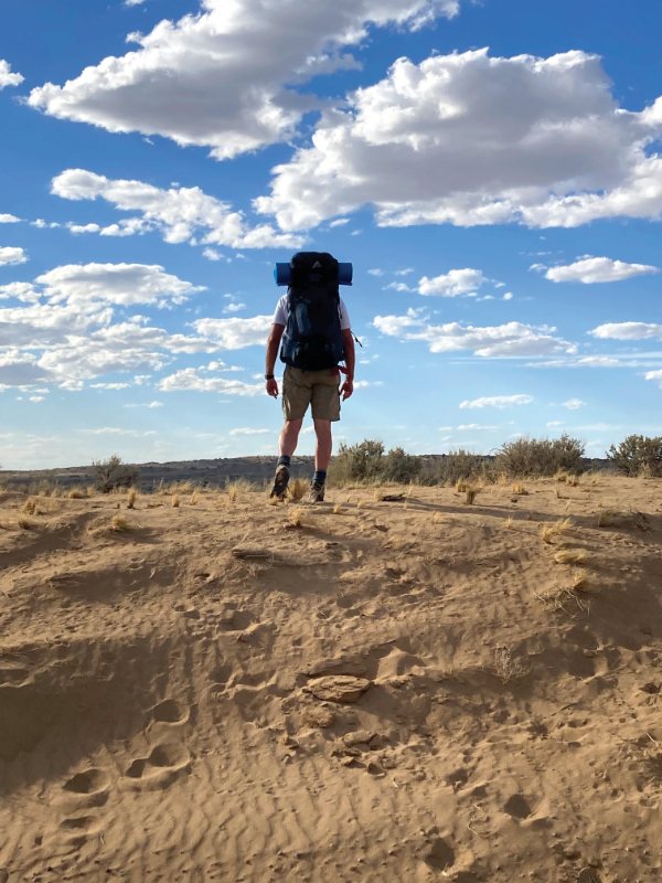
Hiking the North Road became a way to bring this rich history of movement full circle in Scott’s honor. In preparation, I reached out to Scott’s siblings about the pilgrimage and did practice hikes with Scott’s oldest brother, Gary, a Kiowa elder. I made field trips to archaeological sites along the North Road and obtained permission from the nearest Navajo chapterhouse to cross a checkerboard of tribal land. Given that the pilgrimage route traverses rugged desert terrain and requires GPS mapping and logistical planning to follow accurately on foot, I plotted coordinates using Gaia software with drop-off and pick-up points along oil and gas access roads that tear through the North Road.
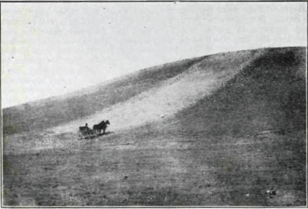
The 360-degree panorama appeared vast and empty as the dust from the drop-off vehicle silently faded miles away in the distance. I stood alone in the middle of an isolated dirt road about a half-day’s hike south of Pierre’s Complex. Early into the hike, I encountered exploratory trenches left by the archaeologists who contributed to the Chaco Roads Project Phase I: A Reappraisal of Prehistoric Roads in the San Juan Basin, published in 1983. This tome of data, maps, aerial photographs, and site drawings was one of the earliest in-depth studies of Chacoan roads. Appendix C provided detailed documentation of selected sites, each numbered with new and revised archaeological information organized into standardized sections, including names of in-the-field data recorders. Peg Van Valen was listed for numerous sites. Peg and I had worked together as backpacking guides in the Sangre de Cristo Mountains of Philmont Scout Ranch in the summer of 1983. In doing my research, I learned Peg had passed away in 2009. As it turned out, my pilgrimage was a way of saying goodbye to two people with connections to the North Road.
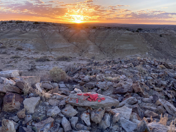
Hiking the North Road proved physically challenging. Although the terrain is relatively flat, the abundance of desert brush, various cacti, and clumps of ankle-turning desert grasses make walking in a direct path impossible. Open spaces between scrubby vegetation consist mostly of shifting sand, which makes footing laborious. I followed intermittent game trails whenever these paths ran in a direction that was reasonably congruent with my course. I also encountered occasional arroyos with 4- to 8-foot vertical drops, forcing me off course as I sought passage down into the flat, sandy bottom and back out again. Pathfinding in this landscape is at best an inefficient zig-zag. Hiking the entire thirty-three-mile route safely in one trip alone and in my sixties became problematic. On this first trip, I managed to complete approximately the middle third of the North Road, which includes the most important archaeological site along the route, Pierre’s Complex.
As I hiked, I constantly wondered how the people of the Chaco Canyon culture constructed and maintained the North Road, thirty feet across, in arrow-straight segments with virtually no deviation, through such formidable terrain. It’s mind-boggling that nearly 400 miles of Chacoan roads have been documented or projected in four states so far. Debate about the purpose and use of the roads ranges from transporting more than 200,000 large timbers needed for construction at Chaco Canyon to symbolic avenues for spirits. More Chacoan-like “roads” are being identified in relatively concurrent archaeological sites in central Arizona, though these shorter segments are mostly interpreted as “racetracks” for ceremonial running events, perhaps like those held at various Pueblos today, rather than processions or pilgrimages.
The act of following a path as a symbolic and literal connection to the past continues among the descendants of the Chaco Canyon culture in the Hopi concept of kukhepya, searching for itaakuku, “our footprints,” among the ruins and potsherds purposely left by the ancestors during their migration to Hopitutskwa, or Hopi land. To the Hopi, these palimpsest pathways in the landscape are spiritual “umbilical cords” to their ancestral past. Scholars point out that some of the trails honored by the Hopi today may have once been Chacoan roads.
The lengths and directions of these Chacoan-era earthworks throughout the Southwest vary widely. Some connected to ruins, shrines, or water sources. Many align with celestial calendar events and/or significant geological features on the horizon line. Others end without an apparent destination. The North Road is the granddaddy of them all.
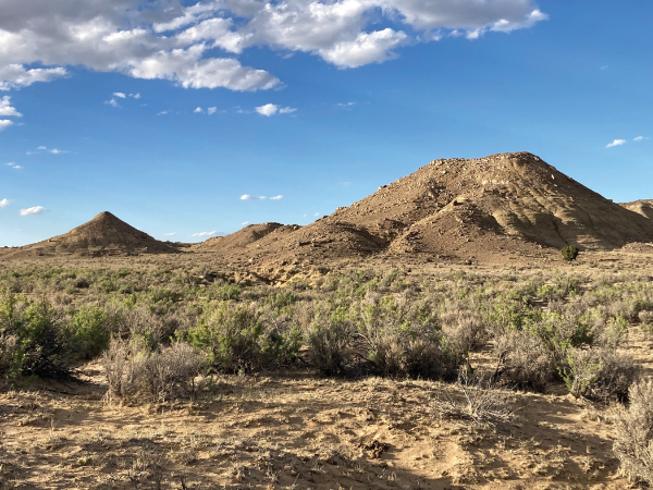
Pottery sherds were evident as I hiked, which confirmed that I was tracking the North Road accurately. Pierre’s Complex, the largest group of Chaco Canyon “outliers” on the North Road, came into view at the end of the first day. From a distance, I recognized the profile of two cone-shaped mesas identified by archaeologists as the Acropolis and El Faro. The two-story structures with attached kivas on top the Acropolis must have presented an impressive profile when seen by pilgrims from below as they approached along the North Road. Only piles of masonry remain today, but outlines of a spur road that formed a grand ramp up the side of the mesa to the ruins remains visible.
A year before the hike, I visited Pierre’s Complex with Rob Weiner, the 2022-2023 Paloheimo Fellow at the School of Advanced Research in Santa Fe. His forthcoming dissertation under the mentorship of Stephen Lekson at the University of Colorado will be a landmark contribution to the abundant literature on Chaco Canyon and a significant reset for studies of Chacoan architecture and roads.
Rob showed me a fire ring atop El Faro. Signal fires visible for many miles may have served as beacons for guiding pilgrims and/or spirits along the North Road. Standing on the top of El Faro, we could draw a straight line visually to Pueblo Alto on the north edge of Chaco Canyon, where the North Road begins twelve miles to the south. This sight line continues in the opposite direction over arroyos and mesas to the next stop on the North Road, Halfway House, ten miles to the north. The North Road is obsessively straight, with total disregard to topography, as if to mirror this sightline.
“Temples all around the world,” Rob explained, “are built like giant houses for gods.” The ruins on the North Road once appeared as oversized houses for deities and attending priests, dramatically perched on a mesa above the North Road. These “great houses” overlook a path that may have symbolically, if not literally, connected the people of the Chacoan world to their place of origin—what the Hopi call the Sipapu—and the ancestral place of spiritual return.
Pottery sherds are everywhere around the ruins. The act of breaking pottery as part of funerary ceremonies has a long history in the Americas. Breaking vessels along the North Road likely had something to do with the cosmology of the people who built and maintained the pilgrimage route. In an animist worldview, all things have a spirit. Made things, like a clay vessel, have a special kind of spiritual existence. Ceremonially breaking these objects can be a powerful act of release.
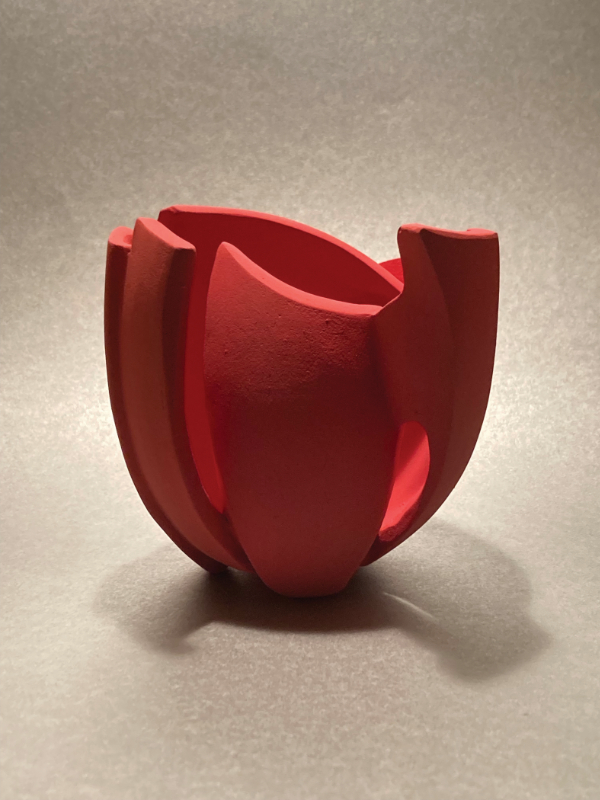
While planning my pilgrimage, I had commissioned ceramicist Kira Enriquez Loya, chair of the department of art at Indiana State University, to create a vessel to break in Scott’s honor. Kira grew up in northern Mexico and is intimately familiar with the ceramics of the region’s Paquimé culture, the artistic descendants of Chacoan ceramicists to the north.
Kira created a vessel about the size and shape of a human heart with a surface that suggested an unfolding flower. As a Mexican artist, Kira recognized a direct link between Uto-Aztecan and Chacoan cosmologies and a common association of flowers as symbols of the spirit world. “I used a flower as reference,” Kira explained, “because it can be a tribute to Scott that you are presenting a flower in this journey and for the reference to the life cycle it represents.” We chose red for the color of the pot to honor Scott’s ancestor, Red Tipi. During the months leading up to the pilgrimage, I studied the way light played over the interlocking shapes and graceful curves of the vessel’s surface. The object I held in my hand was a work of mesmerizing visual motion.
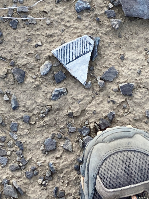
At dawn on my second day of the pilgrimage, I broke the vessel amid the ruins of the Acropolis. The first rays of sunlight over the horizon illuminated the pieces. Casting a sherd to each of the four directions with a prayer, I symbolically released Scott to retrace the Kiowa Odyssey back to the Kiowa homeland and his place of burial in Oklahoma. I made an offering to the ancestors, gathered the remaining pieces of the pot, and continued my hike northward toward Halfway House.
Keith Chino, an Acoma Pueblo friend and ceramist, said to me after the hike, “That’s a fine tribute to your friend Scott. I’m positive he received your prayers—and with a good heart.” In my heart of hearts, the hike was not only a pilgrimage in honor of my Kiowa friend; it was a pilgrimage into American history. William Faulkner famously wrote, “The past is never dead. It’s not even past.” The past remains alive in the landscape of the North Road. Walking among the ruins and potsherds, however, I contemplated how pumpjacks and pipelines are threatening the North Road’s preservation, and I wondered what history will remain alive for future pilgrims in this changing American landscape.
—
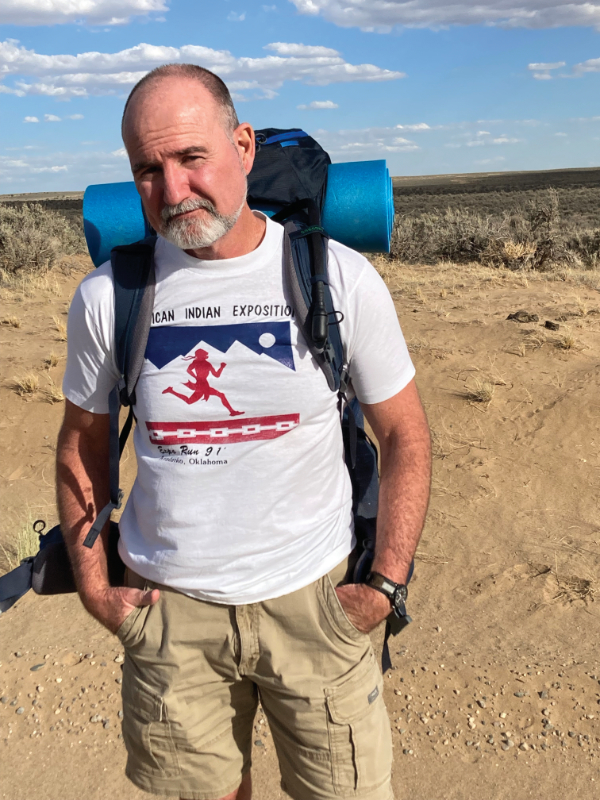
Scott Robinson served as associate professor and director of the School of Art at Stephen F. Austin State University and dean of humanities at Tarrant County College in Fort Worth where he retired in 2020. Scott now lives in Albuquerque and is writing a book about hiking the Great North Road in honor of his childhood friend Scott Tsoodle.