


By Matthew J. Martinez
Photography by Jim O’Donnell
To us, these petroglyphs are not the remnants of some long-lost civilization
that has been dead for many years … they are part of our living culture.
What is stored in the petroglyphs is not written in any book or to be found in any library. We need to return to them to remind us of who we are and where we came from, and to teach our sons and daughters of it.
— Herman Agoyo, (Kaafedeh)
Former Governor, Ohkay Owingeh and All-Indian Pueblo Council Chairman
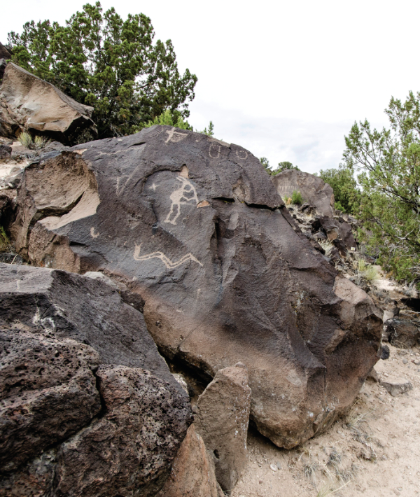
These words provide breath and spirit in the continued work of the Mesa Prieta Petroglyph Project (MPPP), which will celebrate its 25th anniversary in 2024. As a 501(c)(3) nonprofit organization, the mission of MPPP is focused on education and stewardship of Mesa Prieta, or Tsikwaye. This Ancestral Tewa landscape comprises more than 100,000 petroglyphs and archaeological features dating back thousands of years. Located in the northern Rio Grande region, the stories embedded in this place are foundational to sharing New Mexico’s histories and beyond.
Despite an ongoing misrepresentation of being non-literate, Indigenous peoples have always been skilled at documenting stories and movements. We can point to early petroglyphs dating back at least 8,000–10,000 years that reflect movement and migrations. Volcanic eruptions from millions of years ago gave life to a cooled lava flow that became basalt boulders—a perfect rock panel to create images that reflected the natural environment. Such rocks and boulders became useful instruments to design systems to divert water sources and create grid gardens for subsistence. These age-old practices serve as a testament to how land-based people viewed themselves within a larger ecological system. The literature on Southwestern history continuously refers to the harsh and drought environments that Native peoples lived in and often dismisses the vibrant and diverse ecosystems along the Rio Grande region.
Documenting and preserving Mesa Prieta petroglyphs has been a core initiative of the project. More than 80,000 images have been recorded across the mesa by the MPPP. Its recording team has noted numerous other archaeological features, such as check dams, field houses and other structures, and ancestral trails in addition to the abundance of rock images. The vast number of petroglyphs in the region is similar to other major sites in New Mexico such as Petroglyph National Monument in Albuquerque and the Three Rivers site near Tularosa. Approximately eighty percent of the glyphs and other features are on private land. Most of the remaining twenty percent are located on Bureau of Land Management land, with The Archaeological Conservancy owning 181 acres, and Ohkay Owingeh a small amount.
In 2007, what is known as the Wells property was donated by Katherine Wells to The Archaeological Conservancy. The Wells Petroglyph Preserve represents the most concentrated area of petroglyphs on Mesa Prieta and is on the National Register of Historic Places and the State Register of Cultural Properties. Katherine’s story and steadfast passion for preservation is documented in her Life on the Rocks (1999). In 2019, Katherine was awarded a Lifetime Achievement Award by the Historic Preservation Division.
Staff and volunteers at MPPP educate students and the public about Mesa Prieta’s history through school outreach activities and scheduled private tours. Because of the sensitive nature of the preserve, the area otherwise remains strictly off-limits. I often tell my student-athlete son to imagine a large basketball net that covers the entire state of New Mexico. Within every visible square is a cultural property that is interconnected with other squares; and the spaces in between the net are equally significant markers. The history and archaeological record of Mesa Prieta do not stand in isolation but are intricately woven within a surrounding agricultural corridor that, for thousands of years, has sustained people traveling through and establishing vibrant communities. Tewa people regard all life as a continuous movement along a pathway. Seemingly uninhabited ancestral places like Tewa Yógeh (Mesa Verde) and Tsankawi (Bandelier National Monument) are alive and honored in songs and ceremonies. Pueblo people continue to visit such places and maintain these ongoing rrelations to and reverence for place. These places were never left nor abandoned.
The Ancestral Tewa village of Phiogeh (Flicker Place) is situated adjacent to historic Los Luceros. The archaeological record for Phiogeh dates approximately between 1400-1600 (Ortman et al., 2020). Outlines of room blocks are still visible today. Phiogeh is property owned by Ohkay Owingeh and remains off-limits to the public. What is significant to know is that Phiogeh, as well as Saeshu’ Owingeh (Corn Silk Village) down the road, were occupied well before Spanish contact and perhaps may have overlapped in the 1600s. These neighboring ancestral sites remain a continued part of Tewa oral traditions and are significant place markers that convey ancestral occupations and migration stories. It is believed that Tewa ancestors from these villages were the ones who created the thousands of archaic and ancestral (Classic Pueblo Period) petroglyphs along Mesa Prieta.
Phiogeh is intimately linked to the northern Rio Grande valley. According to Scott Ortman, Patrick Cruz, and Arthur Cruz, “A series of natural springs occur within the floodplain between the site and the river. This was a likely attraction to the area prior to development of irrigation infrastructure. The site is situated so that both Tsikumu P’in (Chicoma Peak) and K’uusehn P’in (Truchas Peak), both significant elements of the Tewa cultural landscape, are in view on the horizon to the west and east, respectively” (2020). These mountain ranges provide a marker and context for recognizing existing homelands.
In contemporary times, tribal, city, and state boundaries are often formally defined through the jurisdiction and management of such lands. From a cultural perspective, homelands are vast and ever-fluid. Much like birds and insects which intersect with many ecological systems according to seasons, so too do Indigenous peoples and lifeways. Through Tewa oral histories, we know that people from Phiogeh eventually moved to present-day Ohkay Owingeh. Flicker bird imagery is common at Mesa Prieta. Often viewed as perhaps knifewing bird imagery or other smaller bird petroglyphs, it is clear that people of Phiogeh etched some of these images. We can see a variety of bird petroglyph images that could be interpreted as turkeys, eagles, or macaws. Reasons for this imagery include paying homage or serving as a visual reminder that birds are interconnected to all life cycles.
Situated on Tewa homelands, the New Mexico historic property known today as Los Luceros is a continuum of human occupation. Named after a Spanish colonial family that once lived there, Los Luceros remains a significant cultural connector to sharing the histories of Northern New Mexico and beyond. As a relative newcomer to the region, Los Luceros offers an aesthetically pleasing experience of the historic 148-acre ranch that remains under the operations of the New Mexico Department of Cultural Affairs. Access and engagement with historic sites present opportunities for all communities to experience. The role of historic site staff includes not only what it means to be a good steward of cultural sites, but also of relationships—with Tribes and surrounding communities, both living and ancestral. In 1983, Los Luceros was placed on the National Register of Historic Places. The property is also on the New Mexico State Register of Cultural Properties. These designations can help bridge conversations between historic sites and the larger communities they serve by recognizing how sites are part of age-old traditions and stories.
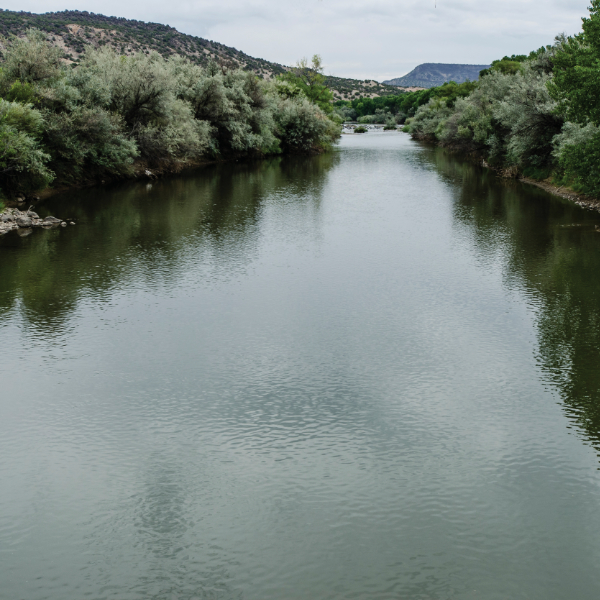
It was common for families from Ohkay Owingeh to visit Los Luceros during the fall to pick apples and trade other fruits and vegetables with surrounding neighbors when I was a kid, growing up down the road. After spending time along this vibrant agricultural corridor, it is clear why people chose to settle in this place. Not only for Ancestral Tewa people and later Spanish families, Los Luceros remains an active site for elk, coyotes, eagles, and many other animals and species that call this place home and depend on its food and water. Elk frequently bugle during the early winter mornings. They have established trails that cross P’oesógeh (Rio Grande River) through Mesa Prieta and commonly gather at the confluence of the Rio Chama and Rio Grande. Deer, elk, and other animal tracks are ubiquitous throughout the area and figure prominently in nearby petroglyphs and through the Rio Grande Gorge area.
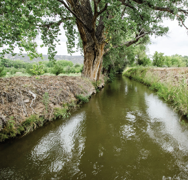
Today at Los Luceros, visitors can experience the beautiful walking trails amidst the cottonwood trees and visit the territorial-style hacienda that houses centuries of history within its walls. The property also includes an eighteenth-century capilla (chapel), Victorian cottage, and farmyard with churro sheep, goats, and burros. The acequia madre was constructed sometime in the 1700s. The use of irrigation systems to support agriculture in this region began with the Ancestral Tewa people. We know that they used a variety of sophisticated methods that included farming on terraces, grid gardens, and water diversions. Once Spanish colonists settled in this area, they quickly realized the need for survival and to develop agricultural practices in their newfound home. The acequia systems had their roots in the Middle East and were brought to Spain by the Moors. The word acequia comes from the Arabic word al-sāqiyah, which means, among other things, irrigation canal.
Spring weather in New Mexico is a transitional time as the earth cleanses itself through wind, dust storms, and spring showers. Around mid-spring, it is a common, intergenerational activity for families and neighbors to come together to clean out the acequias and prepare for a new planting season. For Tewa people, the avanyu (horned serpent) is revered for bringing water and life through the valley. He can be seen in the sky coming through as a lightning figure during a rainstorm or flowing along the acequias. Not only are avanyu representations common as petroglyphs, but today they are evident in the larger Rio Grande style on pottery and weaving designs as a reminder of ever-flowing life.
For norteños, such traditions are honored through San Isidro Labrador, the patron saint of farmers, gardeners, and laborers. Communities gather on San Isidro Day, May 15, to bless the farm fields and acequias. The village of San Ysidro was named for the patron saint of farmers, an eleventh-century Spanish saint. Isidro was a laborer for Juan de Vargas, an ancestor of Don Diego de Vargas. According to Charlie Carrillo, “God rewarded him, as a very holy man by sending an angel to help with the plowing. To get a drink of water for his master, Isidro struck the ground with a gourd and an eternal spring came forth” (Awalt and Rhetts, p. 89). He is commonly depicted wearing blue trousers, a red shirt, and a flat hat, and accompanied by a plow, oxen, and an angel.
These spring activities are central to sustaining ecological lifeways. Water from the acequia madre is utilized to water apple orchards and the fields at Los Luceros. Visitors to Los Luceros can witness the churro sheep enjoying the freshly harvested alfalfa. This can be attributed to continuing acequia cultural practices that give life to people, food, and the surrounding landscapes.
Along this same region, the beautiful village of Estaca figures prominently into this corridor that links the histories of Mesa Prieta and Los Luceros. Many Northern New Mexicans are unaware of its existence and some Estaqueños perhaps prefer it this way. Estaca is a small Hispano village north of Ohkay Owingeh and Española on the west bank of the Rio Grande. The village is defined by its visual marker of La Capillita. This chapel serves to house the statue of San Fransisco, the patron saint of Estaca. In Tewa, this place has historically been referred to as Namponuu, which can be translated as “down at the holes in the earth.” The Ancestral Tewa use of Estaca dates from the 1300s into the 1600s based on archaeological research in the area. And evidence suggests that Ancestral Tewa use of the site was seasonal farming by residents most likely from Phiogeh (Ortman, 2022).
According to Peggy Coyne,
Two large arroyos drain from the east and west sides of the Rio Grande to converge on the river at Estaca, where they deposit silt and force the river into a shallow, braided configuration, making an ideal site for a river crossing. Estaca’s site atop a raised promontory above this crossing of the Rio Grande gave it a strategic importance for both trade and defense. Military maps from the 1840s through 1860s show Estaca or ’Staca’ and note its geographical location near the ford on the Rio Grande and trails leading across Black Mesa to Ojo Caliente (Coyne, p. 35).
We know that ancestral trails set the pattern for key routes to establish New Mexico cities and villages. Perhaps one of the most well-known was the El Camino Real de Tierra Adentro. Built atop a vast network of Indigenous footpaths and trade corridors, this trail connected central Mexico with the people of the American Southwest. Extended in the sixteenth century, it was at one time the longest road in North America.
The colonizing expedition of 1598, led by Juan de Oñate, brought settlers, priests, soldiers, Indigenous guides, and servants into present-day New Mexico. The northern end of that trail ended at Ohkay Owingeh on the west bank of the Rio Grande known as Yungeh (Mockingbird Place). Ancestral trails across Mesa Prieta were just a small part of the expansive networks that were perhaps utilized for trade with many other villages in Northern New Mexico and beyond. We know that trade items such as seeds and food were critical to the survival of people in the area. Because of trade relations across the Americas, Tewa people had access to items such as coral, macaw feathers, and new words and concepts that are still in use today.
We continue to be shaped by Indigenous texts embedded within items such as pottery, weavings, and dance traditions. These are ever continuous, and it is through these movements that long life is created for all people. Tewa history is not referenced within a formal time period and people are not placed within assigned historical categories along a continuum of progress. Tewa naming of newborn babies, as perhaps common among many Indigenous people, is often connected to skywatching and associated relations. Names such as Agóyó Anyéh (Moving Star), Okhúwá Povi (Cloud Flower), Than Tsídeh (Sun Bird), Tsígówänú (Lightning), Kwahténbây (Rainbow), and numerous others, are tied to all things related to above and below worlds. Names may include references to animals, lakes, and mountains as part of interconnected environments. Each village differs in ascribing names which may be given throughout one’s life. Tewa names carry blessings and cultural histories and provide a strong life path for children into adulthood.
One time I asked my sa’yâa, (grandmother) Esther Martinez, about stories she knew about the old railroad tracks that crossed our village property. She recalled the following story when the Chile Line (Denver and Rio Grande Railroad) arrived in 1890 in Northern New Mexico, crossing the Embudo station and cutting through Tewa villages.
My grandfather told me a story about the train, about when the whole village came to see what the train looked like. They [Tewa people] came with cornmeal. Cornmeal is used to pray in Indian whenever they [Tewa people] go anywhere, when they gather medicine from nature they always throw cornmeal and ask for the earth’s permission to get the medicine and tell her what they need it for, before they take it—and that is the same way for pottery clay, always throw cornmeal, ask for clay and tell her what they need the clay for. So, they came prepared with cornmeal when they heard the train whistle. There used to be a hill that came down, where the river [Rio Grande] came around, the train track they had to cut into the hill to make it run straight through. The train whistled loud, you know how it steams loud and sounds like it was breathing hard, so they thought it was alive and they were afraid of the loud sound … [they said] you’re welcome to come here but please don’t be angry, come peacefully, and then they threw cornmeal. It stopped. They said it was breathing hard; [they] thought it must have come from a long way and was tired. That was their first sight. After that they [presumably railroad staff] told the Indian people they could travel for free, for free anytime they wanted, anywhere the train took them. [There would be] plenty of places to sell their pottery. [Pueblo] People sold mostly pottery to the people on the train. They could travel anywhere they want, anytime to sell their ware to other places (Martinez, p.2).
This was the first sight of the ohibay (steam container) for the Tewa people in 1890. No longer in existence, the paths created to lay the tracks are still visible today on the western banks along the northern Rio Grande and surrounding communities. The socio-economic impact of the Chile Line was important to the farmers and residents of Northern New Mexico. For generations the primary mode of production was farming, and the introduction of the railway significantly altered a new wave of subsistence that would be evident in the decades that followed.
The entire northern Rio Grande corridor remains a testament to a vast network of trade and cultural exchange that is very much alive. Those who came before are generally referred to as Ancestors who have a special place in the present physical world. Mesa Prieta, Los Luceros, and the places in between shaped individual lives and communities, affecting the establishment and development of Northern New Mexico. The actions of the Ancestors are encouraging plant growth and stewardship today by enduring positive benefits for the world. Recognition and respect of these cultural places and villages as an international historic region is critical to commemorating our state’s history. People are part of the land within all living things, and not separate from nature. Our human community—as the link between the Ancestors and the unborn—carries the responsibility to be good stewards of these sacred lands. Kúdaawóháa.
—
Matthew J. Martinez, Ph.D., is currently serving as Executive Director of the Mesa Prieta Petroglyph Project. He is a former First Lieutenant Governor at Ohkay Owingeh.
For more information, please visit: www.mesaprietapetroglyphs.org and www.nmhistoricsites.org