


Story and Photographs by Larry Crumpler
Every volcano is like a living thing. They are born, live, die, and leave behind their remains, eventually returning to the Earth as fragmented rock and soil. Sometimes they live in the presence of entire communities of other volcanoes that we geologists call volcanic fields, and sometimes as isolated individuals. Volcanic eruptions have happened in the recent as well as the not-so-recent past in New Mexico, and they will happen again.
Volcanoes are uncommon in most places, yet volcanoes have created features that are part of the everyday landscape for New Mexicans. There are nearly 1,000 centers of volcanic eruption younger than 4 million years old, and many of these are much, much younger than that. Younger features include two of the largest young lava flows on the continent, known as the El Malpais National Monument and Valley of Fires State Park flows, and a young supereruption, the Valles Caldera, an example of a giant volcano formed from a supereruption that now broods in repose on the western horizon of Santa Fe.
New Mexico certainly has a diverse array of volcanoes. There is one that you can drive up at Capulin Volcano National Monument, a classic cinder cone and the easternmost young volcano on the continent. Young lava flows are the canvas for ancient rock art at Petroglyph National Monument, where an Icelandic-style fissure eruption occurred in the recent past. And layered lava flows west of Taos have been cut by the Rio Grande into a deep chasm known as the Rio Grande Gorge. There are young explosion craters like Zuni Salt Lake and Kilbourne Hole of Desert Peaks National Monument, where chunks of the mantle have been blown out onto the surface during violent eruptions not long ago. There are lava flows at El Malpais National Monument that are so young, so vast in extent, that they defy a simple hike. They preserve the intricacies of how lava flows move and form, and are the peer of anything to be found in the recent eruptions of Hawaii.
There are also the “bones” of older supereruptions at City of Rocks State Park and old volcanic sentinels such as Tomé Hill, the site of an important Easter pilgrimage. There is the icon of New Mexico landscapes, Ship Rock, and other volcanic necks, such as Cabezon Peak in the Rio Puerco Valley. And there are many others, lesser-known because there are so many, but as spectacular as any volcano on the continent.
But while we have extolled the wonders of New Mexico on many fronts, its amazing collection of volcanoes appears to have gone “missing in action” and unrecognized; and surprisingly, many New Mexicans are unaware of their presence.
The Importance of Volcanoes in New Mexico’s Landscapes
Volcanoes are an integral and widespread part of the New Mexico landscape. It’s an important association because, over and over again, when someone wants to express why the place we call New Mexico is special, the word “landscape” usually figures prominently in their first sentence.
When the 1878 Governor of New Mexico Territory Lew Wallace famously said, “All calculations based on our experiences elsewhere fail in New Mexico,” he was referring to the political landscape—but it is equally true of the physical landscape. All experience with landscape elsewhere fails to prepare you for comprehending the New Mexico landscape.
Elsewhere, the common experience is that the landscape is a sculpted thing, shaped by erosion of old rocks, but in New Mexico it is as often as not a constructed thing, either uplifted or erupted. It is all dynamic and young, evocative of a thing born and alive rather than carved like a statue from some inert mass. So it invites the imagination on many levels, and is uniquely beautiful on many scales. New Mexico’s landscape is one of its special brands that distinguished it from the rest of the continent. And yet, it is a largely invisible landscape. Despite their recurrence in the art, culture, and beauty of New Mexico, many people are unaware of the presence of its volcanoes or do not recognize them when they encounter them on their daily travels throughout the state.
We have stared at volcanoes in famous paintings and photographed their stark forms, gone hiking, skiing, camping, and hunting on their slopes and craters, marveled at the wildlife and forests that they support, and watched the sun set behind their peaks. While it is difficult to travel anywhere in the state without seeing a volcano, few citizens can see them because they are often invisible, not because they are subtle, but because the uninformed eye cannot recognize them for what they are.
Volcanoes Dot the New Mexico Landscape
But where are all these volcanoes? They occur pretty much throughout the state. The younger volcanoes tend to cluster in a broad swath across the northern part of the state, an alignment generally referred to as the Jemez lineament, probably following ancient structures of the crust slicing diagonally across the state. Many other volcanoes occur up and down what is the single largest natural history characteristic of the state, the Rio Grande Rift. It is no coincidence that where the two trends cross, there is a striking morphological example of a large supereruption caldera, the Valles Caldera.
There was a great mantle warming and break-up of the western United States tens of millions of years ago that started the process of forming the Basin and Range province of southern New Mexico, and that process ultimately initiated the formation of the Rio Grande Rift, and spawned the older great supereruption clusters in southwestern New Mexico, the Datil-Mogollon-Gila volcanic field. Even the stable Colorado Plateau province of northwestern New Mexico was not immune to this flare-up, and created the great centers of now-eroded volcanic features like Ship Rock and surrounding volcanic plugs.

Interestingly, up and down the Rio Grande, every major city and town has nearby an important volcanic landform, almost as though it is a requirement for any center of art and commerce in the state. The great Taos Plateau volcanic field extends west of Taos. And as we have seen, the great Valles Caldera lies across White Rock Canyon west of Santa Fe and forms the backdrop for the Santa Fe Opera.

The Albuquerque Volcanoes, one of the youngest eruptions within the Rio Grande Rift, and the more distant Mt. Taylor volcano, the second-largest young volcano in the state, form the western horizon for the largest city’s sunsets. Low shield-shaped volcanoes lie to the city’s north and south. Socorro lies on the margin of the great Datil-Mogollon-Gila supereruption cluster, as does Silver City. Las Cruces lies within the outline of a buried caldera and is flanked on the west by the Potrillo volcanic field with its impressive Kilbourne Hole and other explosion craters and young lava flows. Even smaller towns are nestled near prominent volcanoes. Who has not seen the large hills west of Los Lunas that are Los Lunas volcano and the Cat Hills volcanoes?
Truth or Consequences and the popular recreation site of Elephant Butte Lake are rimmed with young volcanic centers. And outside the Rio Grande Valley, Wagon Mound, Raton, Clayton, and Grants grew alongside entire fields of young volcanoes and their lavas. Oddly, where the volcanic fields are bigger or where they are particularly young, the cities near them are centers of art and culture.
Rather than being some mystical effect, perhaps the volcanic landscape has influenced the residents over the years with an unusual environment of light and color, and stirred their imaginations with untapped possibilities of exploring untamed terrain.
New Mexico as a Museum of Volcanoes
Once you become aware how common volcanoes are here, the realization dawns on you that New Mexico is actually a giant outdoor museum of volcanoes. There are many different types of volcanoes, some big, many small, and all representing the range of volcanic landforms that are built by different styles of eruption. In New Mexico, there is an example of almost every type of volcano and they are all young, relatively uneroded, and often appear nearly the same now as the day they last erupted. They are so well-preserved that many of us find these to be a bonanza for research into how volcanoes and lava flows work.

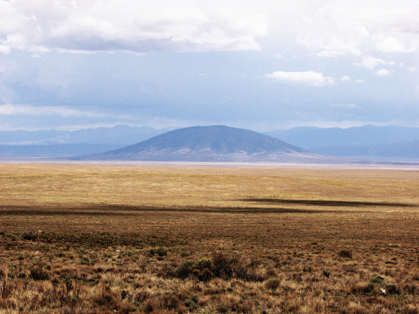
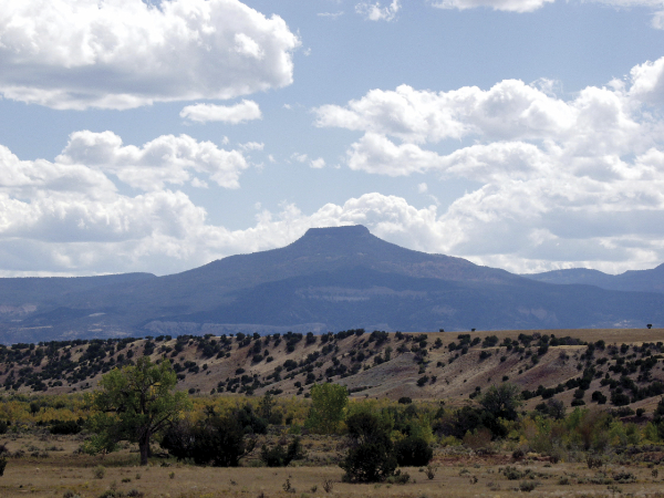
Volcanoes are not all shaped like Mount Fuji in Japan or the conical spires of Central America, the Andes, the Pacific Northwest, or Indonesia. Those represent only one type of eruption. A good example of that type, known as a composite volcano, is Mt. Taylor, where thick, viscous lava flows covered the flank of the volcano layered with ash and scoria, the products of explosive and lava flow eruptions. Mt. Taylor could be thought of as being to the Rio Grande Rift what Kilimanjaro is to the East African Rift.
Another more common type of volcano in New Mexico is the cinder cone, of which two well-known examples include Capulin Volcano and Bandera Crater. These are piles of scoria and liquid spatter, often complex internally if not outwardly, formed by intermittent explosive bursts that rain down near the vents and pile up into beautiful cones. They tend to be gregarious and occur in clusters over large areas in what we call volcanic fields. The area west of Las Cruces, known as the Potrillo volcanic field, is a good example. The western part of El Malpais National Monument, the region between Raton and Clayton, the areas west of Ft. Union and north of Mt. Taylor, the Cat Hills west of Los Lunas, and near Red Hill, at the state line along Highway 60, are just a few other examples.
Even the volcanic necks of the Rio Puerco Valley are the near-surface interiors of eroded cinder cones. Cinder cones are a common volcano type, and many people think these are currently dead landscapes that at one time bubbled with abundant and simultaneous eruptions of hot lava. But the reality is that thousands to tens of thousands of years typically separate the birth, life, and death of each volcano within a volcanic field. So the entire field of volcanoes may span a million years or more in intermittent eruptions; the landscape between eruptions was likely quiet and covered with trees and soil between those individual eruptions, and the area would have looked much as it does today for most of the time.
New Mexico also has a striking collection of explosion craters, called “maars,” after the German word for the small lakes filling similar craters in the Eifel district of Germany. This type has very little cone about them and were formed when hot magma encountered groundwater near the surface at the time of eruption. Zuni Salt Lake between Red Hill and El Malpais is one famous example. Kilbourne Hole in the Potrillo field is one of many maars west of Las Cruces that nestle among the cinder cones there, and even more can be seen in the older volcanic fields around White Rock Canyon and in the field north of Mt. Taylor, or within the Rio Grande Rift such as the margins of Elephant Butte Reservoir.
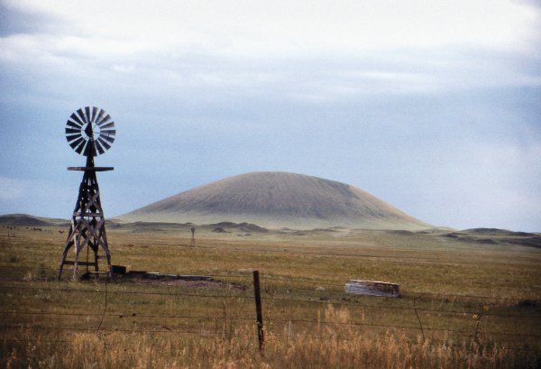
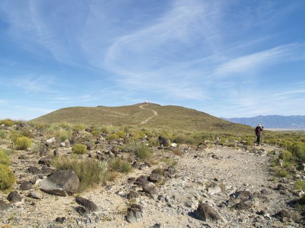
Shield volcanoes are another New Mexico specialty. This type of volcano is so named because in profile it looks like a warrior’s flat shield lying on the ground. The Hawaiian Islands are large examples of this type, but they also occur at much smaller scales as low, broad conical mounds of lava less than a mile across. Maxim Crater near the rest stop between Watrous and Wagon Mound is a prime example.
Another hill, west of I-25 near La Bajada before descending toward Santa Fe, is passed by thousands of commuters every day. This is La Bajada shield volcano. When you drive west down the wide arroyo from I-25 towards San Felipe Pueblo, the great conical hill atop the mesa looming to the west of the pueblo, San Felipe shield volcano, is also a fine example of this volcano type. Cerro Verde in the Lucero volcanic field south of I-40 and Mesita is another outstanding example that to many must look like just an old eroded hill, but take a closer look and you will see multiple lava flows and a summit of small cinder cones. And there are many, many others of this type in New Mexico.

Some volcanoes are really “non-traditional” in shape. Volcanic domes are an example; they form when very viscous magma is piled up at the volcanic vent without much ejection of material into the air. The viscous magma associated with this dome-shaped type of volcano, usually a type of lava called rhyolite, normally goes along with violently explosive eruptions like the one that formed most of New Mexico’s supereruptions.
But sometimes the magma is just less gaseous. It is this type of volcano where you are likely to find obsidian, a dark glassy rock formed when high silica lava quickly chills, often with streaks and bands from its flowing origin. Many of the clusters of volcanoes that preceded the formation of the Valles Caldera and the Datil-Mogollon-Gila supereruptions were of this type. Volcanic domes can be fragile like the stony glass that they are and crumble as they grow.
It is the debris shed off one such dome, along with small amounts of ash, that forms much of the Kasha-Katuwe Tent Rocks National Monument—not ash from the Valles Caldera, which came much later. But volcanic domes also happened after the caldera formation at Valles Caldera, and a ring of volcanic domes form an arc around the floor of the caldera. One diminutive and perfectly domical example is Cerro La Jara on the floor of the Valle Grande right next to the Valles Caldera visitor’s center. Many people probably think this hill is just an old eroded volcanic hill. Not so; it pretty much looked like that when it formed about 50,000 years ago, long after the caldera formed 1.2 million years ago.
And then there are very large-volume lava flows. New Mexico’s large lava flows are numerous, but the youngest example, and the youngest eruption in the state dated at 3,900 to 1,200 years old, is the McCartys lava flow on the eastern margin of El Malpais National Monument. The McCartys lava flow rivals the volume of the great 1783 eruption of the Laki fissure in Iceland, an eruption so voluminous that it remains one of the most globally influential eruptions in recorded history, spawning an increased mortality rate in Europe, contributing to the potato famine, and casting a haze over the northern hemisphere that prompted Benjamin Franklin to speculate that volcanoes could have global climatic influences.
But there is another characteristic of the McCartys lava flow. Besides being one of the largest young lava flows on the continent, it is well preserved because of its youth. Many terms we use to describe the features seen on lava flows were derived from studies of this flow. The flow also exhibits a peculiar characteristic of some large lava flows, and the subject of some of my own recent scientific research: The lavas are inflated, or puffed up. This happens when flows are emplaced on low slopes. The margins begin solidifying as the flow advances slowly, and they eventually hold the interior hot lava back with nowhere to go. So the cooled crust on the lava begins to inflate with the arrival of more lava within. All sorts of phenomena occur, including deep cracks and breakouts that bypass the inflated parts, resulting in a complex interplay of new and not-so-new lava.
There are a few other examples of this inflation process, such as the 1859 flow on the west shores of the Big Island in Hawaii. But despite being younger, the Hawaiian flows are a less perfect example of the process. Besides, the McCartys lava flow, unlike the flat, low landscape and the sea-humidified air of coastal Hawaii, is surrounded by a beautiful contrasting setting of sandstones and mesas in the high and dry air of New Mexico; and the flows erupted in landscape that looked much as it does today. The molds of trees are preserved in many places on the McCartys lava where they were toppled onto the lava flow as it advanced across the valley floor.
The second-youngest eruption, at around 5,000 years old, is another young and large lava flow, the great Carrizozo lava flow. It is the site of the Valley of Fires State Park, one of a handful of state parks that is not a lake but instead focuses on something unique to New Mexico. Another impressive lava flow surrounds Aden Crater in the Potrillo volcanic field west of Las Cruces. Here, too, the lavas are inflated on the low slopes of the rift valley floor.
The Role of Volcanoes in the Cultural Landscape of New Mexico
Many of us use the collection of New Mexico volcanic landforms in research studies to better understand features we are exploring on other planets such as Mars. But the volcanoes of New Mexico are not only a scientific research resource, but a cultural one as well.
The cultural landscape of New Mexico, both in art and history, is littered with the influence of New Mexico’s volcanoes. One of the things that has set the state apart and influenced the minds of creative souls is this unusual invisible landscape sculpted from Earth’s original fire.
Ever sensitive to the special qualities and the living spirit of the landscape, the value of volcanic landscapes did not go unnoticed by the Puebloans. The sites of both ancient and modern pueblos are situated near many of these volcanic landscapes. Taos Pueblo has the Taos Plateau volcanic field, San Ildefonso Pueblo and Santa Clara have the ash sheets of the Pajarito Plateau and Black Butte, Kewa and Cochiti lie near the tent rocks at the margin of the Jemez field. San Felipe, Santa Ana, and Zia ring the southern end of the San Felipe field. And Jemez Pueblo is situated at the south end of great ash flow sheets that rolled off the margins of the great Valles Caldera. Mt. Taylor watches over and is sacred to the Laguna and Acoma Pueblos. And Isleta Pueblo is located on an island of basalt lava flows near the Rio Grande and encompasses lands that include one of the younger eruptions in the Rio Grande Rift, the Cat Hills. Zuni Pueblo is situated near the western tip of a great lava flow that moved down the Zuni River from the Zuni-Bandera-El Malpais volcanic field.
Where there is a pueblo, you are not far from a young volcanic landform.
Casting farther back in time to the Ancestral Puebloans, the Gila Cliff Dwellings were carved into debris shed off the surrounding great supereruptions of the Datil-Mogollon field. Ancestral Puebloan sites were carved directly into the erupted ash flows of the Valles Caldera at Bandelier National Monument. It is unsurprising that many arrowheads, scrapers, and other tools for cutting were made from the obsidian of many of these volcanoes.
Volcanoes and volcanic clusters form many of New Mexico’s uplands and open ranges that provide the resources of forests, grasslands, and mineral-rich rocks, and that may have pre-disposed settlement by Native peoples near volcanoes; however, other factors may have been at play as well. Perhaps the Native American awareness of landscape subtleties allowed recognition of the special character of the volcanic landscapes, a sacred landscape of mountains that are entities with living spirits that provide a pathway to an underworld. For whatever reason, they chose to settle near them; the Indigenous populations were appreciative of the volcanic environments they lived near.
In the recent history of the colonization of New Mexico by Spanish and American settlers, volcanoes were sentinels, waypoints, and refuges in their movements throughout the interior of the new lands. Travelers journeying along El Camino Real de la Tierra Adentro, following the rift from Mexico up to Santa Fe, could hardly avoid the volcanoes that populate the Rio Grande Rift. Even the great and formidable escarpment at La Bajada that separated Rio Abajo from Rio Arriba is the edge of lava flows from La Bajada shield volcano and the Cerros del Rio volcanic field.
At the stop along El Camino Real at Tomé, the dark volcanic rise of Tomé Hill has become a shrine now visited daily and especially on Easter by the faithful. Also on their movement along El Camino Real, travelers were forced from the rugged floor of the Rio Grande Valley and past the great lava flows of La Jornada del Muerto volcano. Today, this volcano’s lava tube is better known for its bat population; however the volcano itself has an extraordinarily unusual structure, an inflated platform that surrounds the edifice, from which the lavas were erupted.
Even the older volcanoes played a role in the history of New Mexico. South of Santa Fe, the Cerrillos, Ortiz Mountain, and San Pedro Mountain are the deeply eroded remains of the Espinoza volcanic field, which formed in that older age bracket 20 to 30 million years ago, some of the lavas of which are preserved on the mesa tops surrounding places like the town of Golden. The heat of the volcanism mobilized elements and, over time, produced deposits of important resource minerals. The Cerrillos, of course, are the site of the iconic mineral used in jewelry: turquoise. Turquoise was mined from the hard rocks of Cerrillos by Native Americans long before it later became the source of the famous mineral of Tiffany fame.
Debris eroded from the nearby Ortiz Mountain and San Pedro Mountain created the gold placers from which gold was extracted, often in private to avoid the Spanish law that said gold was the property of the King. Later the area became the site of the first gold rush west of the Mississippi River, twenty years before the California gold rush.
Moving forward in history to a time when people were arriving across the plains from the East on the fabled Santa Fe Trail, the first sentinels announcing their arrival in New Mexico were the “mounds”—the volcanoes—of the Raton-Clayton volcanic field. Features such as Rabbit Ears were among the first beacons to travelers, who were encouraged as, one by one, they passed Round Mound, a smooth sloped cinder cone, and Wagon Mound, a massive volcanic ridge that resembled a Conestoga wagon. Fort Union was established as an outpost to protect travelers, and many a soldier stationed there must have felt as though they had been sent to the Moon when they saw the volcanic peaks of the Ocaté volcanic field to the immediate west.

Even today, when flying to New Mexico from Chicago across the northeastern corner of the state, you know that you have finally arrived back home when you look down and see the first squiggly lava flows of the Raton-Clayton volcanic field. Since they are the easternmost young volcanic field in the continental U.S., they proudly announce to the air traveler that you are now in the far northeastern corner of New Mexico.
The list goes on and on. But the essential point remains that New Mexico’s volcanoes are and have been a fundamental part of the art, the culture, and the history of New Mexico.
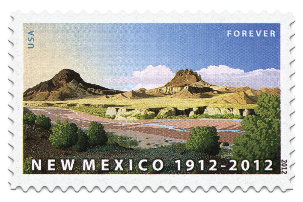
Another place to continue on our journey of familiarization with this invisible landscape of the Land of Volcanoes is the many ways this landscape has been appreciated through art and woven into the culture of New Mexico as a destination for artists. When volcanoes are mentioned, one of the first features that comes to mind for many people is Ship Rock, a veritable icon of the Southwest. Ship Rock is so much a part of New Mexico’s image that it appeared on the official postal stamp celebrating the state’s fiftieth anniversary in 1962. And on the state’s 100th anniversary, another celebratory stamp featured a volcanic scene reminiscent of, and probably selected for its similarity to Ship Rock: the painting by artist Doug West of two other volcanic features, Cerros de Santa Clara and Guadalupe.
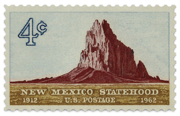
All three are a type of volcanic landform known as “volcanic necks,” because in each case, the top or head of the volcano has been worn away and only its “neck,” the interior hard intrusions of former magma, remain. The Rio Puerco Valley contains dozens of these in a collection that ranks among the greatest concentration of volcanic necks in the world. Even more importantly, they are well exposed and preserved because of the arid environment, lack of vegetation, and relatively rapid erosion in the Rio Puerco Valley. The volcanic necks are a rare opportunity for volcanologists to see the near-surface interior details of small volcanoes that erupted 3 million years ago, their siblings remaining relatively uneroded on the surrounding mesa tops.
Set in a surrounding of much older bright yellow sandstones and shales dating from the time of New Mexico’s great Cretaceous sea and through which they erupted much later, they create a serene and craggy landscape evocative of other worlds. Or, if you are a volcanologist, your mind is twisted, attempting to make sense of the intertwining of scoria, ash, intrusions, and lavas.
All that is required is that you approach one with your volcanic eyes, and they will speak volumes to you.
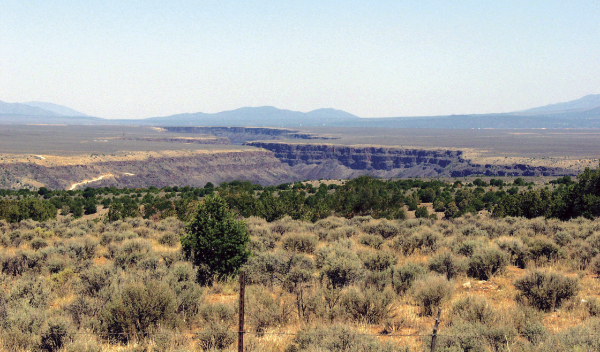
The volcanic landscapes in New Mexico had an early influence on the twentieth-century landscape artist movement centered at Taos. Of course, anyone familiar with the story of the Taos Society of Artists has seen the epic painting by Ernest Hennings, The Rio Grande Gorge, Taos, New Mexico. In fact, the view from the highway just before descending into Taos is often called “the artist’s view.”
Oddly for New Mexico, instead of being created by volcanic activity, it is an eroded feature; like the eroded shape of Ship Rock, the artistic scene of the gorge results from the erosion of an unusually thick sequence of lava flows creating the volcanic landscape through which the Rio Grande flowed. The gorge is a part of the Taos Plateau volcanic field that fills the Rio Grande Rift valley west of Taos, an otherworldly landscape of unusually large and domical volcanoes, somewhat unique among volcanoes in the West, owing their shape as much to summit erosion and the absence of much ash as to their viscous and thick lava flows. In 1971, the gorge was used as an analog training site for Apollo astronauts preparing for their trip to Hadley Rille on the Moon.
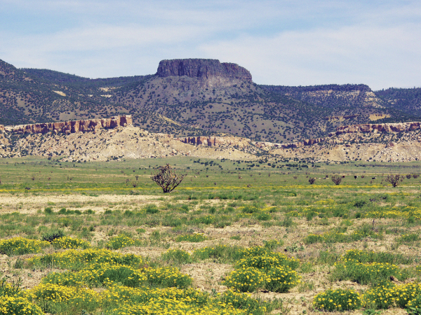
Following the theme of the invisible, or in another case, the misunderstood volcanoes of New Mexico, are the many famous scenes of Pedernal Peak by Georgia O’Keeffe as viewed from many places in the area of Ghost Ranch. Pedernal Peak is not actually a volcano or the site of a volcanic eruption. It is partly volcanic, however, and was sculpted into an unusual flat-topped pyramid, otherwise satisfying the untrained eye’s vision of a volcano. Instead it is capped with the remnant of an old lava flow, a sort of narrow mesa, left high-standing when the surrounding rocks eroded on either side of the valley in which the original lava flowed some 6 million years ago. This is what geologists call inverted topography, and it occurs when hard, massive lava caps and protects otherwise easily eroded rocks underneath the lava flows. The beginning and the end of the lava flow are cut off at Pedernal Peak and only a small portion remains orphaned atop a pinnacle made of sedimentary rocks. Other more expansive mesas in New Mexico are capped with entire fields of even younger volcanoes and volcanic rocks, but Pedernal Peak is an unusually narrow and tall example.
There are many other scenes painted by artists, again of eroded volcanic features that the untrained eye can more appreciate, but not recognize as volcanic. Subjects have famously included Black Mesa near San Ildefonso Pueblo, Canyon Diablo and White Rock Canyon in the Cerros del Rio volcanic field west of Santa Fe, and, of course, Ship Rock. But not all of New Mexico’s preserved volcanoes are unseen; they may be seen just as interesting solitary mountains, if not as volcanic mountains.
The isolated but brooding presence of Mt. Taylor volcano is captured in the series of paintings 30 Views of Mt. Taylor by Mary Sweet, perhaps alluding to its shared origin with the object of another famous series of another volcano, Mt. Fuji in Japan. Other volcanoes are painted in scenes such as Mt. Capulin in Summer by Joshua Martin. The isolated and symmetrical character of many volcanoes invite the talents of artists to capture their sublime presence. There are few other places where the sheer number and range in forms are available for artists.

The Future of Volcanoes in New Mexico
Finally, the future may hold the creation of new volcanoes and the destruction of old ones. Many cinder cones have been quarried for their hard, fine scoria over the years. An entire cone, perhaps one of the youngest eruptions in the Raton-Clayton field, has been removed by quarrying just north of Capulin Volcano. Some of the cones representing the youngest eruptions within the Rio Grande Rift have been quarried away in the Cat Hills in the past. Housing developments encroach on the landscapes formed thousands of years ago in volcanic eruptions. Lava flows that have lain untouched for thousands to millions of years are dug up and blasted away or cut through. And while archeologists provide official reports to document information from sites hundreds of years old, there is rarely a thought among officials that geologists should be brought in to recover the geological data, thousands to millions of years old, exposed in these unique opportunities to learn about past volcanic eruptions.
Unlike the destruction of old growth forests in the wetter climates of the continent, these “old growth” volcanoes are much older and will not regrow on the timescale of human civilization. And wouldn’t it be wonderful if artists could use their skills to imagine how each volcano looked as it was when alive and erupting, much the way they paint detailed scenes of saber-toothed cats when they were alive?
Destruction may not be the future fate of all volcanoes in New Mexico; there may be creation as well. Even now, magmas stir 12 miles down inside the crust between Socorro and Belen, the Socorro magma body, one of just a few “mid-crustal” magma bodies on the continent. Most of New Mexico’s yearly occurrence of earthquakes are centered about this area within the Rio Grande Rift. It is every geologist’s favorite candidate for a future eruption. But that eruption need not happen tomorrow or anytime in the near future; its timeline remains unknown.
Perhaps we should honor these “old ones” that represent the unique volcanological heritage of the state, and the new ones to come, by agreeing to identify a State Rock. Many states have a designated rock, but there is no official New Mexico State Rock—only a mineral and a state fossil, in addition to many species of plants and animals. It seems fitting that there be a State Rock that represents our landscape, and that it should be volcanic.
The rock should probably be basalt, the rock that has formed the top of many of our scenic and beautiful mesas, the canvas for rock art, the cinder cones that served as waypoints for travelers and colonists, and the outlines of some of our majestic mountains, the “old ones” that are so meaningful to all of us in New Mexico.
—
Dr. Larry Crumpler is a self-funded research curator of volcanology and space sciences at the New Mexico Museum of Natural History and Science. Recently he contributed to a new renovation of the museum’s Land of Volcanoes exhibition, where visitors may feel the power and sound of volcanoes, interact with virtual flowing lava, and learn about volcanoes and volcanic rocks around New Mexico from interactive exhibits.