

By Paul Reed
“Our churches are being attacked and our people can’t go to them to pray. It’s a fight against white men with gold in their eyes.”
—Suzan Shown Harjo (Cheyenne and Hodulgee Muscogee)
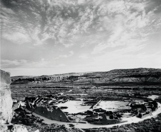
In this tumultuous year of 2020, the wind whistles through an apparently vacant Chacoan landscape, dominated by uplifted sandstone mesas and a few solitary buttes. Above, the sky is a perfect azure, radiant blue contrasting with the soon-to-be-hot morning sun. The pandemic has reduced the normal crowds to just a trickle of visitors and brilliant blue-black ravens nearly outnumber people. For those of us captivated by ancient sites and landscapes, however, the word “vacant” could be no further from the truth.
The Greater Chaco Landscape holds tens of thousands of ancient, sacred cultural sites representing the traditions of multiple Native peoples of the American Southwest. Many of these sites are part of the ancient Chacoan World, dated between 850 and 1200 CE. Modern Pueblo peoples (including the pueblos of Acoma, Zuni, Hopi, Santa Clara, Tesuque, Santa Ana, Laguna, Jemez, Taos, and many others) of today are the descendants of the Chacoan groups who built thousands of great houses, smaller dwellings, shrines, and roadways across the modern Four Corners states.
Beginning in 2011 and accelerating in 2012 and 2013, oil and gas companies punched hundreds of wells into the 5,000-foot- deep Mancos Shale formation at different locations across the Greater Chaco Landscape. With recent advances in hydraulic fracturing (fracking) and horizontal drilling technology, billions of gallons of oil and natural gas became accessible, particularly as the price of crude oil on the world market soared over $100 per barrel. This activity came on very quickly and was not anticipated by very many people in the region.
The Farmington Field Office of the Bureau of Land Management (BLM), the managing agency, moved slowly to regulate these new approaches to oil and gas extraction. It was not until late 2012 that the BLM decided that its 2003 resource management plan (RMP) needed an amendment to properly regulate the fracking and horizontal drilling technologies. The amendment process and drafting of a new Environmental Impact Statement (EIS) was initiated in early 2013 and is still ongoing as of press time.
The BLM was sued in federal court by a coalition of environmental and Native grassroots groups for exceeding its authority to issue permits for drilling under the 2003 RMP. The lawsuit ultimately resulted in several well permits being overturned, but did not substantially impact or slow down development in the Mancos Shale formation. Fortunately, market forces did greatly slow down the juggernaut of drilling in 2014, as a glut of oil flooded world markets and prices declined. Finally, most recently, the current pandemic has brought all new activity in the greater Farmington area to a standstill.
Before delving further into the ongoing oil and gas threat to Chaco’s sensitive sites, I want to briefly set the stage by discussing the history of accessing and protecting Chaco Canyon and its surrounding landscapes.
Chaco’s Early History of Protection and Exploitation
The date of the “discovery” of the spectacular sites in Chaco Canyon is hard to pinpoint precisely. To begin, the notion of discovery is very Euro-centric and insulting to many Native Americans. Even after the migration of people from Chaco Canyon before 1300 CE, we can infer that Pueblo people and other Indigenous groups continued to visit the great houses to reconnect with ancestral places. Abundant references to Chaco exist in many origin stories and oral histories of the modern Pueblos. Thus, it seems reasonable to suggest that Chaco Canyon never passed out of the memory or experiences of Pueblo people.
As to Chaco’s “rediscovery” by Euro-Americans, visits by Spanish explorers and other travelers (from the early 1600s forward) undoubtedly occurred, but because of the destruction of Spanish records during the Pueblo Revolt of 1680, little or no documentation has survived into the present. More surprising, perhaps, and certainly unexplained, is the absence of written descriptions of the Chacoan great houses from about 1700 through the early 1800s. Historical records indicate that during that time, the Spanish launched numerous punitive expeditions against Navajo and Apache Indians in areas west of Santa Fe and the Rio Grande. Some of the routes described passed through the Chaco country; the name Chaco or Chaca was first applied to the canyon and surrounding lands at this time, in the eighteenth century. Although it is unlikely that he ever visited the canyon, Spanish cartographer Bernardo de Miera y Pacheco identified the general area around Chaco, and particularly to the south, as “Mesa de Chaca” in his 1776 map.
The earliest documented trip through Chaco Canyon was made by a Spanish military officer named Jose Antonio Vizcarra, who was pursuing Navajos accused of raiding settlements in 1823. Vizcarra’s pursuit went down Chaco Wash, and he observed and recorded several large pueblo sites in the canyon. Additional accounts, mostly made by Spanish military expeditions, mentioned Chaco over the next several decades, but it was not until 1849 that the first comprehensive descriptions and maps of the Chaco Canyon great houses were made.
At the end of the Mexican War in 1848, the United States was in possession of millions of acres of new Western lands. With these new lands came clashes with the Native American inhabitants, and a military expedition was launched into Navajo country in 1849. Under the command of Col. John Washington, military governor of New Mexico, the expedition also included Lt. James Simpson and two brothers, Richard and Edward Kern, both accomplished artists. As the company passed through Chaco Canyon, taking the trail west towards the Chuska Mountains and Navajo country, Simpson was assigned a detail to explore Chaco and document the spectacular sites within.
A man of considerable diligence, Simpson set about creating a detailed recording of the great houses, while Richard Kern prepared the first known drawings and reconstructions of the pueblos. So accurate were his descriptions and drawings that they stood the test of time and were not surpassed in detail nor quality for nearly 100 years. The group’s Spanish guide Carravahal, from San Ysidro, New Mexico, identified most of the largest ruins by name. Simpson applied these names to the sites, and they are still in use today.
Francisco Hosta, then the governor of Jemez Pueblo and one of the Native American guides for the group, reportedly told Simpson that Montezuma and his Aztec people had built the ruins in Chaco on a northern sojourn before heading south to construct the urban center at Tenochitlan, Mexico. Apparently following Hosta’s lead, Simpson speculated that the ruins were built by the Aztecs or another Mesoamerican kingdom, and so initiated a period of many years of ill-informed understanding of the origins of the Chacoan great houses.
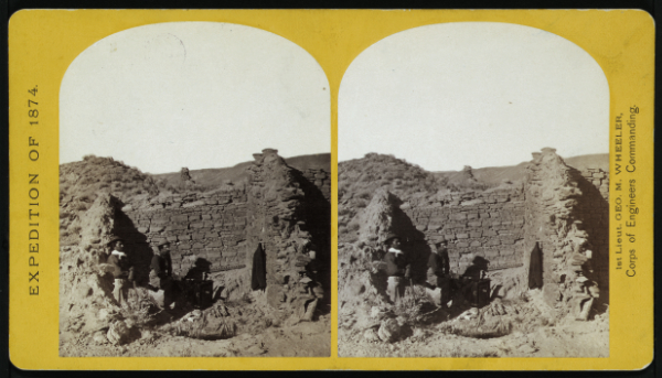
Simpson’s journal and the drawings of Richard Kern made the spectacular structures of Chaco Canyon known to only a few people, and the “secret” of Chaco remained hidden for several decades. The 1870s, though, saw renewed interest in Chaco Canyon. Photographer William Henry Jackson and William Henry Holmes together made a trip in 1877, as part of the US Geologic and Geographic Survey of the Territories (also known as the Hayden Survey). The Hayden Survey hired the same Jemez guide Francisco Hosta, who had led Simpson through Chaco. Jackson spent most of a week studying sites in Chaco and exposing photographic plates. Unfortunately, Jackson was experimenting with a new technique, and none of his photographs of Chacoan houses came out. It was decades before Jackson was able to duplicate some of his shots and produce photographs of Chaco. Most importantly, perhaps, was Jackson’s determination that the ruins were not built by the Aztecs or another vanished tribe, but were the ancestral homes of the modern Pueblo people of New Mexico and Arizona.
Large-scale excavations at sites in Chaco Canyon began in the 1890s, during the period that archaeologist David Hearst Thomas describes as the “collecting phase” of American archaeology. Eastern museums began to sponsor work across the American West, to collect artifacts that were believed to be the last remnants of vanishing Native American cultures and societies. Accompanying all of this work was the racist idea that Native tribes represented primitive examples of humanity that required study before these groups were vanquished and acculturated, and “joined the rest of American society.”
Sites across America, particularly in the West, were looted with massive, unscientific projects designed to collect as many artifacts as possible in the shortest possible time. This burst of activity, which lasted for decades, resulted in incredible damage to and outright destruction of many cultural sites. The passage of the Antiquities Act in 1906 stopped some of the looting of America’s ancient heritage and instituted a permit process to provide some level of control over excavations and removal of artifacts.
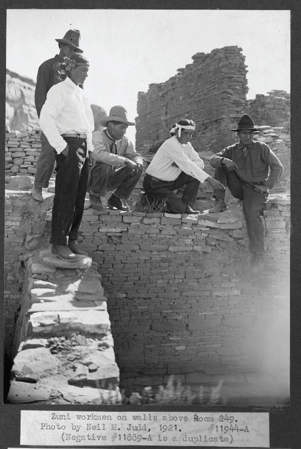
Somewhat miraculously, given the unrestrained digging and the volume of artifacts that flowed eastward in the late eighteenth and early nineteenth centuries, as well as very different ideas about what constituted “preservation,” the great houses of Chaco Canyon were not destroyed and still stand more than 120 years later. Nearly all of the credit for this goes to the Navajo and Pueblo masons and workers who have labored tirelessly for the National Park Service preservation crews at Chaco since the 1930s.
More recent archaeological and scholarly research on Chaco’s amazing sites has covered considerable ground. Among other issues, much of this interpretation has sought to explain the presence of so many dwellings and ceremonial sites in an apparently inhospitable climate. The Chaco region today receives less than 7 inches of rain yearly (on average). During its heyday from 850 to 1150 CE, many decades produced much more rainfall than the long-term average, and the now-entrenched Chaco Wash flowed freely at the surface many months in good years. Thus, our twenty-first-century perception of Chaco as a dry, forbidding place is hardly accurate. Beyond this, few of the archaeologists and scholars writing or thinking about Chaco are of Native American descent. It is fair to say, then, that widely consumed interpretations of Chaco from the perspectives of Pueblo descendant communities are rare.
Although the early days of American anthropology saw close connections between archaeological work on ancient sites and ethnographic studies with tribes, by the 1940s, these approaches were considered passé and archaeology went on a decades-long path of greater reliance on scientific methods. Unfortunately, this change heralded a huge shift in the field away from significant interaction with the living descendants of the Ancestral Pueblo groups who built places like Chaco Canyon. In recent decades, things have shifted again, in large part due to the passage of the Native American Graves Protection and Repatriation Act (NAGPRA) of 1990.
In brief, NAGPRA requires museums to: 1) Identify all human remains, funerary items, and items of cultural patrimony; and 2) Consult with descendant Native American tribes to repatriate items and rebury human remains. Although the law has resulted in some well-publicized cases of conflict between archaeologists and Native Americans (the Kennewick Man case, in particular), many of the interactions between Native Americans and museum staff or archaeologists have been seen as productive and positive.
One important legacy of NAGPRA, in addition to the repatriation of human remains and sacred items, is greatly increased communication between archaeologists, anthropologists, museum specialists, and Native American groups. Although this contact has not immediately resulted in new interpretations of Native sites, I believe it has created many more opportunities for cooperation and the broadening of what have been Euro-American-dominant narratives of the ancient American past. My own participation in an ongoing NAGPRA process has allowed me to make many important contacts with individuals and leaders from various tribes, and has enriched my understanding and appreciation of their perspectives on their own histories.
I am happy to say that American archaeology is in the midst of a decolonizing operation. In brief, many of us non-Native archaeologists feel that Native interpretations of sites and control of archaeological research and collections are long overdue. It should go without saying that many of our Native American colleagues and friends are in agreement and are ready to support and embrace this process. I believe we are on the cusp of fundamental changes in the pursuit of archaeological work in the United States.
Protecting Greater Chaco from 2014 to 2020
With regards to the current oil and gas development threats on Chaco Canyon, Native American groups have taken critical leadership roles in the multiyear protection effort. The organization with which I work, Archaeology Southwest, became involved with efforts to protect Greater Chaco in early 2014. We have been in close contact with the offices of United States Senators Tom Udall and Martin Heinrich and Congressman Ben Ray Luján. We have partnered with a number of environmental and preservation organizations during the last several years, including the National Trust for Historic Preservation, National Parks and Conservation Association, the Wilderness Society, New Mexico Wilderness Alliance, Conservation Lands Foundation, and PEW Charitable Trusts. We created a Chaco Coalition and immediately began outreach to Native tribes affected by oil and gas development. Since 2015, I have met with a number of Pueblo leaders and representatives from the Navajo Nation.
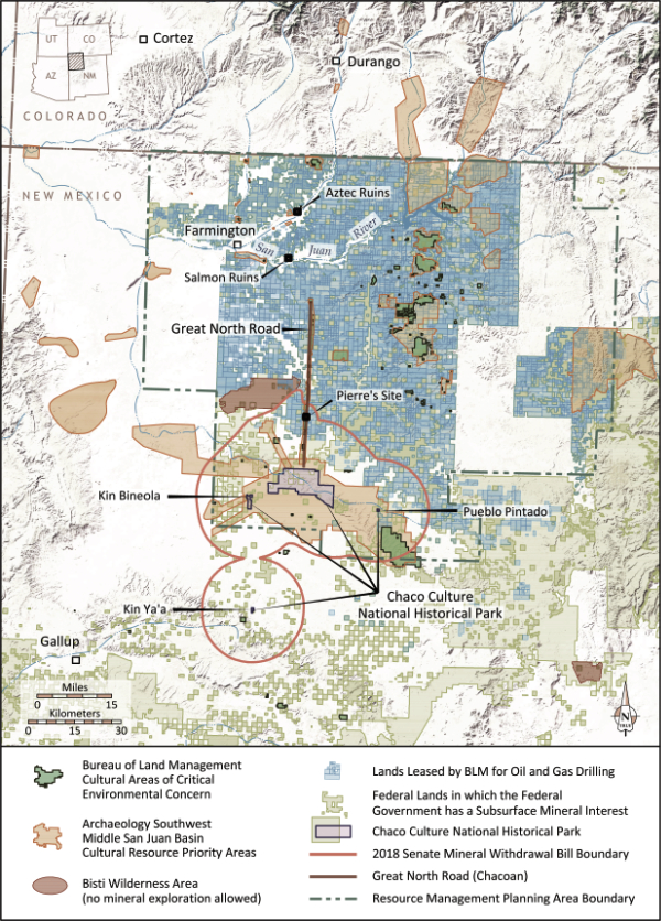
As the process continued, the All Pueblo Council of Governors (APCG), representing the nineteen New Mexico Pueblos and Isleta del Sur (in Texas), took a leading role in advocacy. The APCG passed several resolutions calling for protection of the Greater Chaco Landscape and asking that the BLM and Bureau of Indian Affairs work closely with Pueblo people as the resource management plan amending process progressed. The Pueblo governors also endorsed a series of measures that would go a long way toward protecting the magnificent cultural resources and modern-day residents of the Chaco area from oil and gas development, including supporting a 10-mile cultural protection zone around Chaco Culture National Historical Park that would be off-limits to oil and gas development. Most recently, the APCG has partnered with the Navajo Nation in 2017 and 2018 to press the agencies for additional protections across the Greater Chaco Landscape.
The National Congress of American Indians passed a resolution in October 2017 calling on the Department of the Interior to issue a moratorium on all oil and gas permitting and leasing in the Greater Chaco Canyon Region to protect traditional cultural properties and sacred sites in the region until the BLM and Bureau of Indian Affairs initiate and complete an ethnographic study of cultural landscapes across the Greater Chaco region and finish the management plan and environmental impact statement.
Sites within the boundaries of Chaco Culture National Historical Park are protected from oil and gas and all other development. The park holds nearly 3,500 cultural and historic sites that date back to 10,000 BCE. Just beyond Chaco’s boundaries, however, very few protections exist for thousands of cultural sites. Because of this, our Chaco Coalition and the APCG began pushing in 2016 for a cultural protection zone around Chaco and its outliers. In 2018, the concept was greatly advanced with a U.S. Senate bill introduced by Senators Udall and Heinrich. Although the 2018 Senate bill did not advance, it built momentum for the idea. In 2019, the U.S. House of Representatives passed H.R. 2181, the Chaco Cultural Heritage Protection Act of 2019. A companion bill was introduced in the Senate in late 2019 (S. 1079; essentially the same bill from 2018). The Senate bill is currently in committee and is very unlikely to pass in 2020.
Also, in 2019, New Mexico’s Commissioner of Public Lands Stephanie Garcia Richard issued an executive order to prohibit leasing of state trust lands for oil and gas development. The order covers nearly 73,000 acres of land within 10 miles of Chaco’s boundary and is in place until 2024.
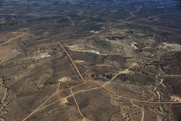
The basis for protecting a 10-mile zone around Chaco Canyon derives from two primary facts: This area is much less developed and more pristine than the area beyond 10 miles; and the area contains a dozen significant and largely unprotected Chacoan great house communities with hundreds of sites. From the air, it is clear that at about 10 miles from the Chaco Park boundary line, the Greater Chaco Landscape begins a serious transition. South of the northern 10-mile line, the landscape is relatively pristine. Certainly, there is some development within this zone—limited oil and gas facilities and some power lines and pipelines that cross the area, but the 10-mile protection zone is largely unimpacted by oil and gas development. North of that northern 10-mile boundary, the landscape begins to change, and shows the effects of industrial development of the oil and gas resources that lie beneath the surface.
Although less than twenty percent of the Greater Chaco Landscape has been surveyed archaeologically, we have a strong sense of the range and diversity of archaeological site types. Because much of the land is and has been home to Navajo people for many years, cultural studies have been completed by the Navajo Nation several times since 1970 to identify sites important in Navajo history. What we lack is knowledge of cultural sites of importance to modern Pueblo people. Of course, many of the Ancestral Pueblo archaeological and historic sites are very important to modern Pueblo groups. But there is a large gap in knowledge because the Pueblo tribes have not been afforded the opportunity to visit the landscapes of Greater Chaco and identify ancient places of importance.
Understanding the lack of important data regarding Pueblo traditional sites across the Greater Chaco Landscape, we partnered with the Pueblo of Acoma in 2018 to begin this important work. The Acoma team visited a number of locales across Greater Chaco and reconnected with ancestral landscapes and sites. The Acoma project resulted in a comprehensive report on Acoma’s connections to the Greater Chaco Landscape. Currently, the Acoma Tribal Council and Governor are reviewing the document prior to public release to ensure that confidential information is not revealed. A similar project across the Greater Chaco Landscape is in the planning stages with the Pueblo of Zuni, but has been slowed by the COVID-19 pandemic.
The BLM and BIA released draft planning documents in February 2020, including the RMP amendment and environmental impact statement for the nearly 3 million-acre planning area in northwestern New Mexico. Despite years of input from the APCG, the Navajo Nation, individual Pueblo tribes, Ute Mountain Ute, Jicarilla Apache, and many environmental and preservation groups, the action alternatives proposed were woefully inadequate to protect the Navajo families living at ground zero above the Mancos Shale formation and the ancient heritage represented by thousands of cultural and historic sites. Only one of the alternatives provided for no new leasing within 10 miles of the Chaco park boundary. The agencies’ chosen path forward shows very little concern for protecting Greater Chaco’s fragile cultural resources. The public review and comment period ended on September 25, 2020, and after reviewing the thousands of comments submitted, the agencies will issue the final documents sometime in 2021.
In summary, Chaco’s complicated history has seen multiple waves of exploitation, exploration, interpretation, and preservation. Despite this history, the current oil and gas development threats are unprecedented. Although BLM and BIA took seven years to finish their RMP amendment and EIS planning documents, the final versions do not adequately protect the Navajo families living on the landscape currently or the thousands of cultural sites that date back 12,000 years. To those of us who have worked on this issue for years, it is abundantly clear that the BLM and BIA should protect larger pieces of the remaining landscape, particularly areas surrounding Chacoan great house communities and areas identified by Native American pueblos and tribes as traditional cultural places and sacred sites. With the advances in various technologies, including LiDAR scans of large landscape tracts and our work with the Pueblo of Acoma, it is clear that cultural sites important to New Mexico’s tribes are not being identified during cultural resource work. Continuing with the current approaches to resource protection will result in losses of additional undocumented cultural resources and will inflict further negative impacts to the Greater Chaco Landscape.
Further, consistent with their obligations under Federal law, the agencies must incorporate and use significant new information about the Greater Chaco Landscape that has been provided to them by the tribal and archaeological communities. The recently completed Acoma Project demonstrates the need for Native American experts to identify their own cultural resources in the field prior to leasing and development.
Ultimately, I ask the agencies to work with the many stakeholders to find new and creative ways to protect and preserve what remains of the ancient Chacoan and Puebloan landscapes.
—
Paul Reed has been a preservation archaeologist with Archaeology Southwest since 2001. He lives north of Taos, New Mexico. Reed’s most recent writing is an edited book (with Gary M. Brown as co-editor) entitled Aztec, Salmon, and the Pueblo Heartland of the Middle San Juan (SAR Press, 2018). During the last six years, Reed has been working to protect the Greater Chaco Landscape from the effects of expanded oil-gas development associated with fracking in the Mancos Shale formation.